

The forecast in detail until Wednesday – The state apparatus is ready – The recommendations of the Civil Protection
Bad weather is in progress which affects our country and has received the name “AVGI” by the EUMETNET team for southeastern Mediterranean.
The Emergency Deteriorating Weather Bulletin issued on 27/01 has been updated according to the latest forecast.
High pressure in the northwestern Balkans combined with low pressure in the eastern Mediterranean causes gale force winds with a further drop in temperature over the next two days and locally heavy rains in the southernmost parts. Snowfall will occur from Thessaly and further southin the mountains and semi-mountains even in areas with a lower altitude.
Watch the course of the bad weather live:
Analytically:
A. Snowfall will occur:
a) Thessaly – Sporades: Today Monday (29-01-24) in mountainous and semi-mountainous areas (mainly Magnesia) and from the evening hours also in areas with a lower altitude (indicative 200-300m). The phenomena will intensify from the early hours of Tuesday (30-01-24) and will gradually weaken during the night.
b) Eastern Continent: Today Monday (29-01-24) in mountainous and semi-mountainous areas (mainly Viotia – Fthiotida) and from the evening hours and in
areas with a lower altitude (indicative 200-300m). The phenomena will intensify from the early hours of Tuesday (30-01-24) (mainly Boeotia) and gradually from the early hours of Wednesday (31-01-24) they will weaken.
c) Evia: Today Monday (29-01-24) in mountainous and semi-mountainous areas and from the evening hours and in areas with a lower altitude (indicative 200-300m). The phenomena will intensify from the early morning hours of Tuesday (30-01-24) and gradually from the early morning hours of Wednesday (31-01-24) they will weaken.
d) Attica: Today Monday (29-01-24) in mountainous and semi-mountainous areas mainly in the north and from the evening hours and in areas with a lower altitude (indicative 300-400m). The phenomena will intensify from the early hours of Tuesday (30-01-24) and snowfall will occur even at a lower altitude mainly in the eastern, northern and western regions. From the night the phenomena will gradually weaken.
e) Northern and eastern Peloponnese: Today Monday in mountainous and semi-mountainous areas and from the night and in areas with a lower altitude (indicative 300-400m). The phenomena during the midday hours of Tuesday (30-01-24) will temporarily intensify and from the morning hours of Wednesday (31-01-24) they will weaken.
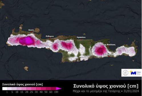
f) Crete: Today Monday (29-01-24) in mountainous and semi-mountainous areas. The phenomena will intensify from the morning hours of Tuesday (30-01-24) and will weaken from the evening of Wednesday (31-01-24).
B. A lot gale north northeast winds 9 and locally 10 beaufort they will blow:
a) From the early morning hours of Tuesday (30-01-24) initially in the northern and gradually in the central and southern Aegean.
b) Her Wednesday (31-01-24) the stormy north winds will be maintained in the Aegean but from the midday hours in the north they will be limited to 8 Beaufort and will gradually weaken.
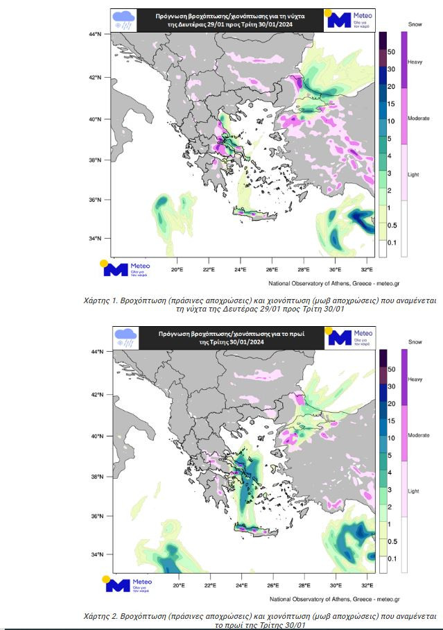
C. Heavy rains and storms are forecast in places from the early hours of Tuesday (30-01-24) mainly in the Sporades, Evia, the Cyclades and Crete. The phenomena will weaken from the early morning hours of Wednesday (31-01-24) in the Sporades, Evia and the Cyclades and gradually from the afternoon hours in Crete.
More details on the weather development in the regular and emergency weather bulletins on the EMY website (www.emy.gr). Forecasts will be updated every twelve hours.
Civil Protection is on increased alert – The recommendations
The General Secretariat of Civil Protection (civilprotection.gov.gr) of the Ministry of Climate Crisis & Civil Protection, has informed the competent government agencies involved, as well as the regions and municipalities of the country, so that to be on heightened alert for civil protectionin order to immediately deal with the effects of the occurrence of severe weather phenomena.
Alongside, the General Secretariat of Civil Protection recommends that citizens be particularly careful, ensuring that self-protection measures are taken against risks arising from the occurrence of severe weather phenomena.
It is noted that the Region of Attica is assisting in Eastern and Western Attica, where snowfall is expected total with:
- 45 snow plows
- 3 trucks
- 2 loaders
- 4 JCBs
- 1 Bobcat
In particular, in areas where heavy rainfall, storms or gale-force winds are expected to occur:
- To secure objects which, if carried away by severe weather conditions, may cause damage or injury.
- Make sure that the gutters and downspouts of the houses are not blocked and are working normally.
- Avoid crossing torrents and streams, on foot or by vehicle, during storms and rainfall, but also for several hours after the end of their event
- Avoid outdoor work and activities in marine and coastal areas during severe weather events (risk of lightning strikes).
- Take shelter immediately during a hailstorm. Take shelter in a building or car and do not leave the safe area until they are sure the storm has passed. Hail can be very dangerous for animals too.
- Avoid passing under large trees, under posted signs and in general areas where light objects (e.g. pots, broken glass, etc.) can become detached and fall to the ground (e.g. under balconies) .
- To faithfully follow the instructions of the local authorities, such as Traffic, etc.
In areas where snowfall and frost are expected:
If they are going to travel by car:
- To be informed about the weather and the condition of the road network
- Have anti-skid chains on their vehicle and a full tank of fuel
- To travel, if necessary, preferably during the day preferring the main roads
- To inform their relatives about the route they are going to follow
- Change their travel schedule to avoid peak weather conditions
- To faithfully follow the instructions of the local authorities, such as Traffic, etc.
If moving on foot:
- Dress in several layers of light clothing rather than a heavy garment and wear appropriate footwear to avoid slippery injuries
- To avoid unnecessary movements during the peak of the phenomena (heavy snowfall, freezing conditions)
For information and announcements regarding the prevailing situation and the passability of the road network due to the inflow of flood waters into it or due to snowfall and frost, citizens can visit the EL.AS website. www.astynomia.gr.
For more information and self-protection instructions from severe weather, citizens can visit the website of the General Secretariat of Civil Protection at civilprotection.gov.gr
Source: Skai
I have worked as a journalist for over 10 years, and my work has been featured on many different news websites. I am also an author, and my work has been published in several books. I specialize in opinion writing, and I often write about current events and controversial topics. I am a very well-rounded writer, and I have a lot of experience in different areas of journalism. I am a very hard worker, and I am always willing to put in the extra effort to get the job done.


