

Positions that have launches – in detail the beaches and areas – over 12,800 earthquakes from January 26 to February 8
Over 12,800 earthquakes has identified a total of Santorini-Amorgos Zone, from January 26 to February 8, 2025, the EKPA Seismology Laboratory (SS), with mechanical learning methods and with strict criteria to ensure the quality of the results.
According to the daily seismic data analysis data (without the use of mechanical learning methods) of the EKPA seismology laboratory, 102 earthquakes have been recorded on 9 February, of which 14 with sizes M≥4.0 and 2 to M≥4.5, while the largest earthquake It was noted at 21:05:40 (Greek time) and was in size M = 5.0.
Continuous landslide during the evolving seismic sequence and their impact on the natural and structured environment of Santorini
The research team of the Department of Geology and Geoenvironment has been following its concomitant phenomena on the island of Santorini from the beginning of the evolving earthquake sequence. The EKPA’s geoscientists have collected data and have made observations that allow them to capture all areas that have been hit by landslides to date and to renew their spatial distribution with new data.
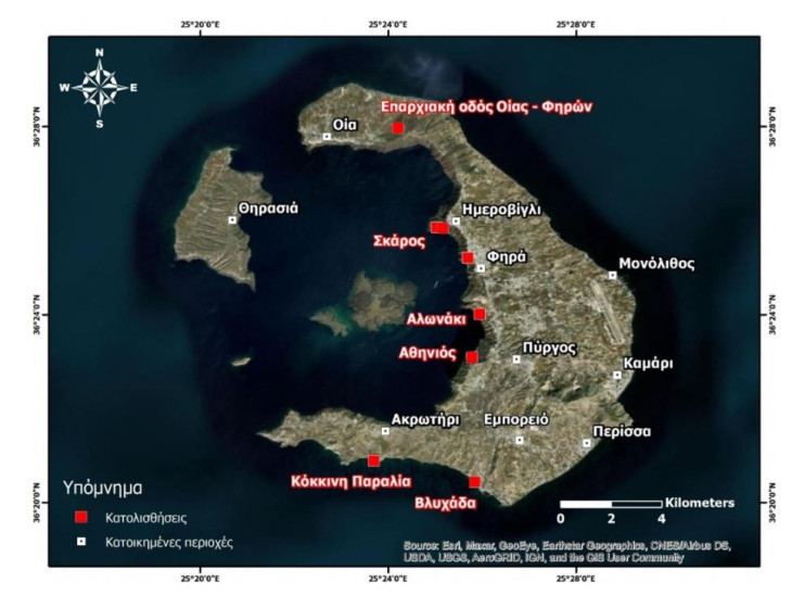
The positions that have been labeled are found not only on the slopes of the caldera but also outside. More specifically:
- In the southern coastal part of Santorini, outside of the caldera,
- In the center -east section of Caldera slopes,
- in the northern part of the island.
The first area includes landslides that occurred:
- In the sloping of the red beach and
- On the slopes upstream of the Vlychada beach.
The second area contains landslides marked:
- On the slopes upstream of the port of Athinios,
- In slopes at a distance of 1.5 km north of the port of Athinios (location of an threshing floor),
- On the slopes upstream of the old port of Fira,
- on sloping downstream of the daytime and
- In the slopes of the Skaros area in Imerovigli
The third area includes landslides that occurred on the provincial road of Fira-Oye.
A common feature of all positions is the presence of slopes with large slopes, unstable volcanic materials as well as geo -geoysics from earlier landslides. However, the effects of recorded landslides are different from position to position.
On the Red Beach, due to the downfall of rocky pieces, the volume of accumulated materials increased on the basis of the slopes of the beach. It should be noted that the beach has not been accessible for years due to rocky cuts.
On the beach of Vlychada, the effects are not point, but extend to its long length. The mobilization of the unstable masses and their accumulation on the basis of its almost vertical slopes has limited its width to a large extent. However, due to its wave action and lithology, the beach is expected over time to return to the previous situation after the redistribution of the geobe in the coastal zone.
On the slopes of the port of Athinios, landslides were limited. Port facilities, passenger waiting area, catering businesses, shops and the outdoor parking space, which are developed in the coastal zone, were not affected by recorded travel.
In the north of the port of Athinios, landslides occurred in slopes that develop far from elements of the structured environment (houses, networks and infrastructures), while part of the unstable materials ended up at sea.
Further north, upstream of the Old Port of Fira, in Imerovigli and Skaros, the recorded phenomena occurred on a sloping downstream of the residential areas (Fira, Imerovigli), which grow on the brow of Caldera. Similarly, with Athinios, there was no impact on the structured environment.
In the northern part of the island, along the road network leading from Oia to Fira, the rock falls resulted in the passage of vehicles from the area to be careful.
This approach presents the landslides affected areas of Santorini, which are currently implemented by the Civil Protection Authorities of non -structural measures, which include banning residents and visitors to areas and prohibition of vehicles in specific sections of the road network adjacent to the adjacent. the positions of increased landslide risk. These positions should be prioritized further, after the seismic sequence is completed, and receive effective structural measures, appropriately adapted to the volcanic landscape and the unparalleled natural beauty of the island.
It is noted that coordinator of the Interdisciplinary Risk and Crisis Management Committee is Efthimios Lekkas, Om. Professor of Department of Geology and Geoopervalos.
Members of the Interdisciplinary Risk and Crisis Management Committee are:
Antonarakou Asimina, Professor and President of the Department of Geology and Geoenvod
Arkadopoulos Nikolaos, Professor of Surgery, President of the Medical School
Vassilakis Emmanouil, Associate Professor
Diakakis Michael, Assistant Professor
Evelpidou Niki – Nikoletta, Professor of Geology and Geoenvod
Kaviris George, Professor of Department of Geology and Geoenvironment
Kartalis Konstantinos, Professor of Physics Department
Layu Pagona, Professor of Epidemiology, Dean of the School of Health Sciences
Lekkas Efthimios, Om. Professor of Department of Geology and Geooperimon,
Mavroulis Spyridon, Scientific Associate of Department of Geology and Geoenvironment
Picoulis Emmanouil, Professor of Medical School
Stavrou Pelios-Dimitris, Assistant Professor of Psychology
Hatzichristou Chrysi, Professor of Department of Psychology
Responsible for the promotion of the project and actions of the Commission is the member of the Department of Communication and the Media, Mr. Dimitris Koutsobolis.
Source: Skai
I have worked as a journalist for over 10 years, and my work has been featured on many different news websites. I am also an author, and my work has been published in several books. I specialize in opinion writing, and I often write about current events and controversial topics. I am a very well-rounded writer, and I have a lot of experience in different areas of journalism. I am a very hard worker, and I am always willing to put in the extra effort to get the job done.


