

Satellite images released on Tuesday (18) help reveal the magnitude of the tsunami that hit Tonga last weekend. The real size of the damage could not be fully known, as the country in the Pacific Ocean is experiencing information isolation after the eruption of the Hunga Tonga-Hunga Ha’api volcano led to the downfall of internet and telephone lines.
Authorities in Australia and New Zealand also revealed details that help to account for the impact that the waves and ash had on major Tongan cities. The two countries, which are spearheading efforts to help the archipelago, sent flights to assess the damage.
The British newspaper The Guardian reported that the New Zealand mission captured areas of ash-covered forest and many landslides on the islands of Tongatapu and Kolomotua. According to Reuters, the images of the military still show “catastrophic” destruction on the island of Atata and “from extensive to catastrophic” in Fonoifua, Niniva, Nomuka and Mango.
Tonga has 176 islands, 36 of which are uninhabited.
The international airport has not been compromised, but it remains inaccessible, with the runway, which appears to have been flooded, still covered in mud and dirt. The Australian Minister for the Pacific, Zed Seselja, said in an interview with local TV that the terminal is only expected to reopen this Wednesday (19).
The New Zealand chancellor, Nanaia Mahuta, reinforced the information, adding that large Hercules C-130 planes with humanitarian aid could only land with the runway free of ash from the volcano. According to her, the country has already sent two ships with drinking water and medical supplies.
Satellite images show magnitude of tsunami impact in Tonga
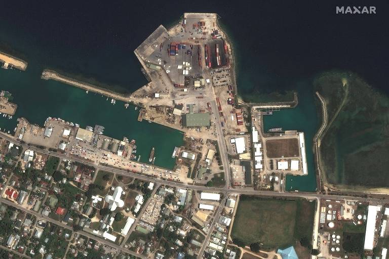
The port facilities in the country’s capital, Nukualofa, on 29.Dec.21, before the eruption of the Hunga Tonga-Hunga Ha’apai volcano and the tsunami, and this Tuesday, 19.Jan.22 – Maxar Technologies / Reuters
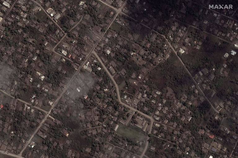
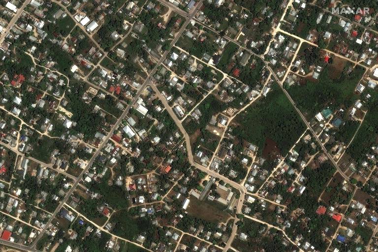
Houses in a neighborhood of the Tongan capital Nukualofa before the eruption and tsunami, on 29.Dec.21, and this Tuesday, 18.Jan.22 – Maxar Technologies / Reuters
The United Nations said a distress signal had been detected in the Ha’apai Islands. The New Zealand mission also reported that damage had been identified along the entire west coast of the main island, Tongatapu — where the capital, Nukualofa, is home to the country’s main resorts.
According to Seselja, the local authorities are having difficulties in the efforts to evacuate the most remote islands, where access is even more complicated, for the removal of all the inhabitants who were left homeless or displaced.
The United Nations Office for the Coordination of Humanitarian Affairs indicated that “further volcanic activity cannot be ruled out”. The island of Hunga Tonga-Hunga Ha’apai all but disappeared after the explosion, according to satellite imagery from about 12 hours after the eruption, making it difficult for volcanologists to monitor ongoing activity.
This Monday (17), the first death in Tonga caused by the tsunami was confirmed in the United Kingdom. A 50-year-old British woman who was missing had her body found by her husband, according to information provided by her brother in Hove, in southern England.
Nick Eleini told reporters that the most likely hypothesis is that Angela Glover was washed away while trying to save her dogs. Her husband, James, managed to cling to a tree and save himself — it’s unclear what happened to the animals. Angela worked with the rescue of abandoned dogs in Tonga.
The Guardian and Reuters on Tuesday cited a second death confirmed in the archipelago, without details of who the victim was and under what circumstances the death took place. Seselja told Australian TV that authorities had not yet received information on significant numbers of victims, but stressed that this could be due to difficulties in establishing communication with Tonga.
On Sunday (16), the Peruvian press reported the death of two people drowned in the region of Lambayeque, in the north of the country, after the record of exceptionally high waves, attributed to the eruption in the Pacific.
This Monday, the country confirmed another impact of the tsunami felt in South America. According to the Ministry of the Environment, at least 3 kilometers of coastline in the province of Callao, central Peruvian region, received oil, which would have leaked in the process of unloading a Repsol oil tanker because of the violence of the waves on Saturday. Some beaches have been isolated for cleaning.
The underwater volcano Hunga Tonga-Hunga Ha’apai erupted on Saturday afternoon (15), at local time (dawn in Brasilia), and triggered tsunamis in Tonga, Japan and American Samoa. According to Fiji officials, the eight-minute eruption was heard “like distant thunder” more than 800 kilometers away.
The Tongan navy confirmed on Tuesday that waves on the island of Ha’apai reached 10 meters high. Previously, meters had recorded waves as high as 83 centimeters in Nukualofa, the Tongan capital, and approximately 60 centimeters in Pago Pago, in American Samoa, according to the Pacific Tsunami Warning Center.
According to New Zealand Prime Minister Jacinda Ardern, the main submarine communication cable with the archipelago was impacted due to the power outage, which is being restored in parts of the islands. According to the BBC, communication could take two weeks to fully resume in Tonga.
The Red Cross estimates that at least 80,000 people may have been affected by the tsunami.
.


