

The Aegean and Crete are among the few European regions that can expect normal temperatures this summer, while generally hot and dry conditions will prevail.
The common conclusion reached by meteorological services of the Balkansbut also representatives of major global forecasting centers that are pioneers in research in the field of seasonal forecasts. our country that the probability of being warmer this summer than the average of the summers 1981-2010 is 70% the same hot 20% and colder only 10%.
The Aegean and Crete will have normal temperatures
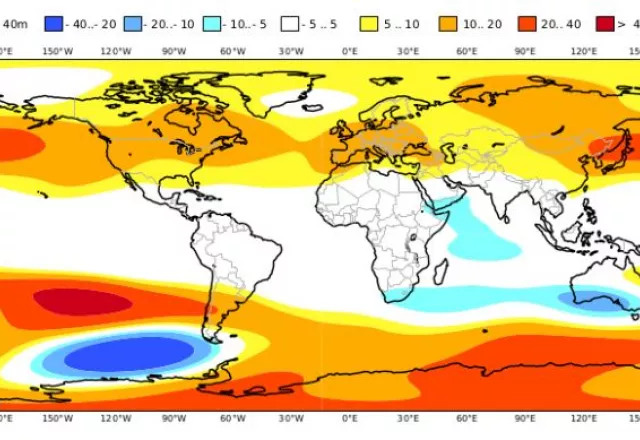
According to the National Meteorological Service, according to the latest results of seasonal numerical forecast models, with the exception of the Aegean and Crete, where the northerly flow pattern probably continues and the average temperatures of the quarter do not seem to deviate from normal, in the rest of the regions the summer is forecast to be relatively hot. The central and northern parts of our country have the greatest chances for this to happen, where the estimated positive deviations reach 1 Celsius.
For the summer 2022 (June – July – August), we have selected, for presentation and commentary, the deviations from the normal values, the temperature at 2m, the precipitation (rainfall), the geodynamic altitudes at 500 hPa, as well as its deviations atmospheric pressure at the surface, as they arise, both from the ECMWF long-term model and from the multi-modelsystem. At this point we should mention that the climatology, both of the ECMWF and of all the models that make up the multi-modelsystem, refers to the period 1993-2016, ie the prices presented are deviations from the average values of this period.
The maps are available from the C3S (Copernicus) service and can be searched together with the results of all the models and parameters that implement the C3Smulti-modelsystem on the website: https://climate.copernicus.eu/charts/c3s_seasonal.
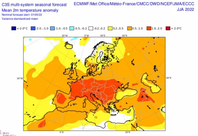
The ECMWF, for most of the European continent, predict warmer than normal. Exceptions are areas of northern Europe, the southwestern tip of the Iberian Peninsula and areas of the southeastern Mediterranean (including the Aegean and Crete). It is important that in the central parts of the European continent, positive deviations of the temperature from 1 to 2 degrees Celsius are estimated, with a probability of over 70%, and in fact, in the wider region of the northern Balkans they exceed 2 degrees.
Focusing on Greece, the ECMWF only in the Aegean region (mainly central-south) and Crete predicts normal temperatures for the season. Across the rest of the country it estimates generally warmer than normal conditions, with the highest probability of this happening in central and northern Greece, where the estimated positive deviations range from 0.5 to 1 degree Celsius and in the northern border probably a little more.
The multi-model largely agrees with the ECMWF forecast and this fact strengthens the “certainty” of the forecast. In general, as we have noted in the past, any differences observed between ECMWF and multi-model are to be expected, precisely because of the multi-model structure as a synthesis of climate models.
We remind you that these forecasts are an average picture of the June-July-August quarter. The estimate for a relatively warmer summer, in some areas, may not necessarily lead to the conclusion that there will be heat waves in these areas with unusually high temperatures, as temperatures could simply be stable just above normal temperatures. throughout the quarter. On the other hand, warm invasions, especially in the Mediterranean, in the summer season are a recorded event and, climatically at least, can not be ruled out. In the same sense, the conclusion about normal temperature values in some areas does not mean that hot episodes are ruled out in these areas, but that they can simply be alternated with relatively cold intervals.
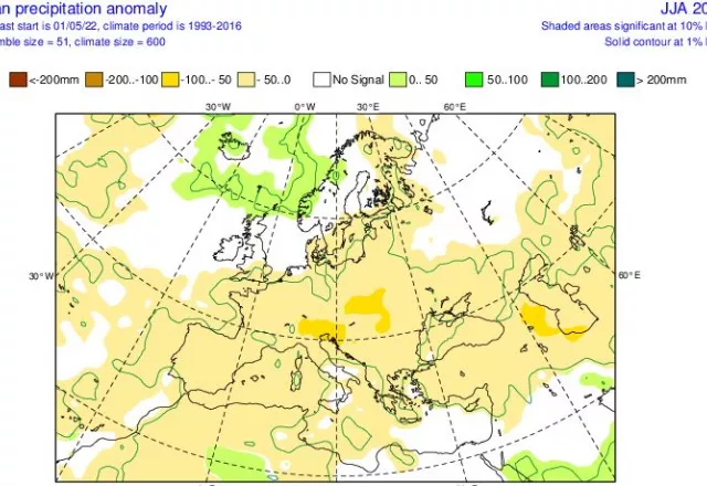
In terms of precipitation (rainfall), the ECMWF forecasts drier than normal conditions in most of the European continent and only in the northern parts normal conditions are forecast and locally in Scandinavia-northern Britain relatively wetter.
Here, however, it is worth noting that for many parts of southern Europe and especially for the Mediterranean regions, anyway during the summer months, zero rain levels are the normal conditions.
Especially for Greece, according to the ECMWF, the possibility for a normal summer in terms of drought has the northwestern Greece and the islands of the eastern Aegean. For the rest of the regions, it forecasts drier conditions than normal, with the highest probability for this in eastern Macedonia-Thrace.
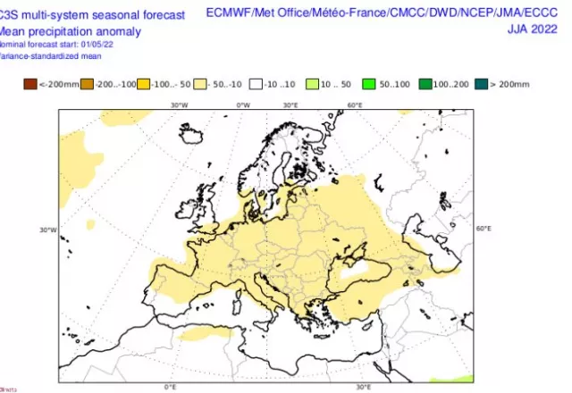
The multi-model agrees with the ECMWF for drier than normal conditions in most of the European continent and rather normal conditions in the northern parts and the UK, but it is worth noting that it differs by estimating normal conditions throughout the Mediterranean Sea.
At this point we must not forget that the rainfall in the summer season comes mainly from storms, with these phenomena often having a strong local character.
Because, to a large extent, the processes in the atmosphere are driven by the circulation at 500hPa, the forecast maps (ECMWF and multi-modelsystem) with the deviations of the geodynamic heights at this level are also presented.
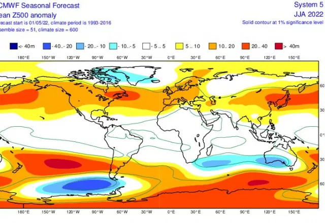
Both the ECMWF and the multi-model predict the presence of a high pressure system in general over the European continent and the North Atlantic Ocean. Neutral or negative deviations of the geodynamic altitudes at 500hPa are predicted in the region of Greenland – Iceland and possibly in the eastern Mediterranean.
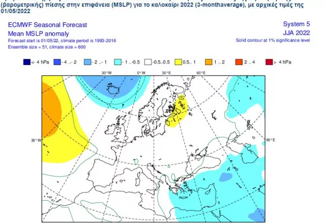
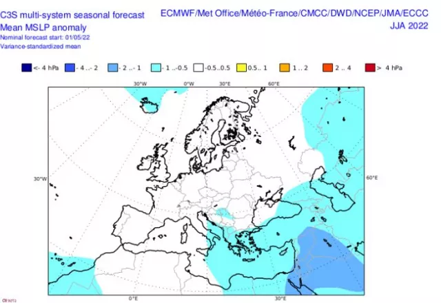
Examining the atmospheric pressure distribution maps at the surface, and focusing on the European area, the ECMWF does not provide for significant deviations from the mean conditions for the whole of Europe, with the exception of the Aegean-Eastern Mediterranean region where it estimates a negative atmospheric pressure deviation. The multi-model estimates a negative deviation in a wider region, which includes the central Mediterranean Sea, southern Italy, most of the Adriatic Sea and the entire Greek region.
The combination of the relatively higher pressures in Central Europe – Balkans with the relatively lowest in the southeastern Mediterranean, during the summer season marks in our region, the presence of annual winds (meltemi), with the frequency and intensity of their dependence directly depends on how strong this combination will be, in other words how big will be the difference in atmospheric pressure between central Europe – the Balkans and the southeastern Mediterranean. The annuals, as north winds, contribute to the cessation of high summer temperatures mainly in the Aegean, but also in eastern mainland Greece, something that is clearly reflected in the temperature maps at 2m, which we mentioned above.
Finally, with a brief reference to the factor that largely determines atmospheric circulation, ie the oscillation of the South Pacific Ocean (ENSO), the estimation that the La Niña phase was in a state of attenuation is still valid, but does not seem to complete the cycle in the summer.
In closing, let us recall that the long-term / seasonal forecast tries to describe the evolutionary trend of air circulation on entire continents or on the entire planet. Therefore, seasonal forecasts should be treated with relative caution, taking into account that their result will represent a large percentage of their reference time (40 – 60%), but in no case should they be rejected, excluding the prospect of improvement.
I have worked in the news industry for over 10 years. I have a vast amount of experience in covering health news. I am also an author at News Bulletin 247. I am highly experienced and knowledgeable in this field. I am a hard worker and always deliver quality work. I am a reliable source of information and always provide accurate information.

: US Economy Avoid a recession")


