

Floods also in Rethymnon – North Evia and eastern Sterea at the center of the storms in the next few hours – Detailed forecast for the development of the weather – Improvement from Sunday
Its passage is sweeping bad weather from the central and northern islands. Many problems with flooding phenomena were recorded in Thassos and in the islands of the Sporades, especially in Skiathoswhich turned into… a lake!
In the next few hours, the phenomena are expected to occur mainly in parts of Thessaly and the Sporades, as well as in Eastern Sterea, with North Evia being at the center. Rains are also expected in Attica, especially in the north of the prefecture. From Sunday, it is expected that the phenomena will weaken and the weather will improve throughout the territory.
In more detail the prognosis of the EMY for the Saturday:
In Macedonia, Thessaly, Sporades, eastern Sterea and Evia, strong rains and storms in places, which will be accompanied by a high frequency of lightning and in places by hail and strong winds.
The temperature will drop significantly mainly in the north and east of the mainland.
MACEDONIA, THRACE
Weather: Increased clouds with rain and sporadic thunderstorms. The phenomena, mainly in central Macedonia, will be strong in places, from the evening they will gradually weaken.
Winds: Northerly 4 to 6 Beaufort.
Temperature: Up to 26 degrees Celsius and in Thrace 2 to 4 degrees higher.
IONIAN ISLANDS, EPIROS, WESTERN Mainland, WESTERN PELOPONNISE
Weather: A few clouds transiently increasing with local showers and in the midday and afternoon hours in the mainland possibly isolated thunderstorms mainly in the mountains. Since evening improvement.
Winds: North northwest 5 to 6 and in the Ionian 7 and possibly locally 8 Beaufort.
Temperature: Up to 31 degrees Celsius.
THESSALIA, EASTERN CONTINENTA, EASTERN PELOPONNISUS
Weather: Increased clouds with rain and sporadic thunderstorms. The effects in the Sporades and until the afternoon in Thessaly and eastern Sterea will be strong in places.
Winds: From north directions 4 to 6 and from the evening to the north local 7 Beaufort.
Temperature: Up to 29 degrees Celsius.
CYCLADES, CRETE
Weather: Cloudy and intermittent rain and possible isolated thunderstorms.
Winds: Northwest 4 to 6 Beaufort.
Temperature: Up to 28 and in Crete up to 30 degrees Celsius.
EAST AEGEAN ISLANDS – DODECANISE
Weather: In the islands of the northern Aegean, increased clouds with rain and sporadic storms, possibly strong in places and weakening of the phenomena from the evening. A few clouds in the Dodecanese.
Winds: Northerly 4 to 6 and from the evening locally 7 Beaufort. In the south northwest 4 to 5 Beaufort.
Temperature: Up to 29 degrees Celsius and in the north 3 to 4 degrees lower.
EUBOEA
Weather: Rains and sporadic storms. The phenomena will be strong from time to time mainly in northern and central Evia.
Winds: From north directions 4 to 6 and from the evening locally 7 Beaufort.
Temperature: Up to 26 degrees Celsius.
ATTICA
Weather: Cloudy with local rain and intermittent thunderstorms, possibly strong in places mainly in the north. Weakening of the phenomena from the evening.
Winds: Northerly 4 to 5 and east local 6 Beaufort.
Temperature: Up to 28 degrees Celsius.
THESSALONIKI
Weather: Increased clouds with rain and sporadic thunderstorms. Gradual improvement since late evening.
Winds: North northwest 4 to 6 Beaufort.
Temperature: Up to 24 degrees Celsius.
Sunday weather forecast
Detailed forecast for Sunday:
In the east and south temporarily increased clouds with local rains and, in the morning hours in Thessaly, Sporades, eastern Sterea and Evia, sporadic storms. From midday the rains will be limited to the mainland and Crete, where isolated storms will occur, while from the evening the weather will improve. In the rest of the regions, few clouds, temporarily increased in the continental areas in the midday and afternoon hours, when local rains will occur mainly in the mountains.
Winds will blow from north directions 4 to 6 and in the Aegean locally 7 Beaufort.
The temperature will rise slightly and return to normal levels for the season. In the northern continents and the islands of the Aegean it will reach 28 to 30 degrees and in the rest of the continents 30 to 32 degrees Celsius.
MACEDONIA, THRACE
Weather: Clouds temporarily increasing with local showers in the early morning hours and improving quickly. In the midday and afternoon hours the clouds will increase again and there will be local rain and possibly isolated storms mainly in the mountains of eastern Macedonia.
Winds: From north directions 3 to 5 and in the morning hours in central Macedonia up to 6 Beaufort.
Temperature: From 17 to 29 degrees Celsius. In western Macedonia the minimum is 2 to 3 degrees lower.
IONIAN ISLANDS, EPIROS, WESTERN Mainland, WESTERN PELOPONNISE
Weather: Generally clear. In the midday and afternoon hours, local clouds will develop in the continental areas, so it is possible that there will be local rain in the mountains.
Winds: Northerly 3 to 5 and from noon in the northern Ionian locally 6 Beaufort
Temperature: From 19 to 31 degrees Celsius. In the interior of Epirus the minimum 2 to 3 degrees lower.
THESSALIA, EASTERN CONTINENTA, EASTERN PELOPONNISUS
Weather: In Thessaly, the Sporades and eastern Sterea cloudy with local rains, in the early hours of the morning sporadic storms and rapid improvement. In the midday and afternoon hours, the clouds in the continental areas will increase again, so it is possible that temporary rains will occur mainly in the highlands of Thessaly.
In the rest of the areas few clouds, temporarily increased in the midday and afternoon hours, so it is possible that there will be temporary rain in the mountains
Winds: From north directions 4 to 6 and in the early morning hours locally up to 7 Beaufort. From noon gradually weakening.
Temperature: From 19 to 32 degrees Celsius.
CYCLADES, CRETE
Weather: Cloudy with local rains mainly in Crete, where there will also be sporadic storms. Gradual improvement from the afternoon.
Winds: North northwest 4 to 6 and in the Cyclades locally 7 Beaufort. Gradual weakening from the afternoon and from the west.
Temperature: From 21 to 30 degrees Celsius.
EAST AEGEAN ISLANDS – DODECANISE
Weather: A few clouds in places increasing in the north until the afternoon and gradually generally clear.
Winds: Northerly 4 to 6 and possibly locally up to 7 Beaufort.
Temperature: From 22 to 30 degrees Celsius. In the north the maximum is 2 to 3 degrees lower.
EUBOEA
Weather: Cloudy with local rain, sporadic storms in the early hours and improvement from noon.
Winds: North northwest 4 to 6 and in the early hours locally 7 Beaufort. From noon gradually weakening.
Temperature: From 20 to 27 degrees Celsius.
ATTICA
Weather: Cloudy with scattered showers at first, possible isolated thunderstorms mainly in the north in the early hours, and improving quickly.
Winds: Northerly 4 to 6 Beaufort, with gradual weakening from the afternoon.
Temperature: From 20 to 30 degrees Celsius. In the east and north the maximum 2 to 3 degrees lower.
THESSALONIKI
Weather: Clouds temporarily increasing with a chance of local rain in the early morning hours and improving quickly. In the midday and afternoon hours, clouds will develop again, so it is possible that there will be temporary rain in the surrounding mountains.
Winds: North northwesterly 4 to 5 Beaufort with gradual weakening from noon.
Temperature: From 18 to 29 degrees Celsius.
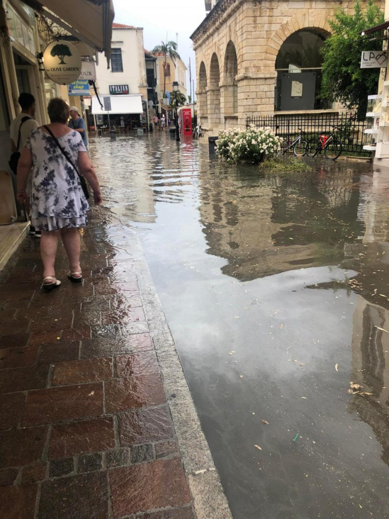
Venice… Skiathos – Rivers, the streets from the torrential downpour
Skiathos has been feeling the deterioration of the weather since yesterday, with heavy rain and storms. Tourists and locals stayed in their hotels and homes, it said magnesianews.gr.
The rain has been falling non-stop since last night and Skiathos remains at the center of the bad weather. The island of Sporades has been filled with tourists, who have been looking for shelter in the last few hours, with most of them staying in their hotels. Locals say the rain was necessary to cool them down and they hope it won’t leave any problems behind.
The rain started at 10.30pm on Friday night and continued until midday on Saturday. “Until this hour in Papadiamanti street, the residents have been hiding to protect themselves, while the tourists have been worried about their movements, because the weather has spoiled their mood” notes a resident of the island, who uploaded the following video to the internet.
In this we see roads flooded and visibility reduced. Skiathos and its Authorities are on alert, with the situation for the time being characterized as controlled…
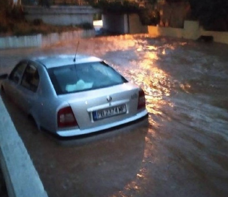
In the “whirlwind” of bad weather, Thassos: Houses and hotels were flooded, cars were swept away
All-night “battle” with bad weather gave by the inhabitants of Limenaria and Potos I’llas well as from the heavy downpour roads, houses and hotels were flooded and vehicles were swept away.
In accordance with kavalanews residents from 2 am were trying to save their properties from the fury of the rain.
The heavy rainfall caused multiple problems, as floods occurred in houses, hotels, buildings, while at the same time the Fire Department was also mobilized for traffic accidents and vehicle drifts from the rapids.
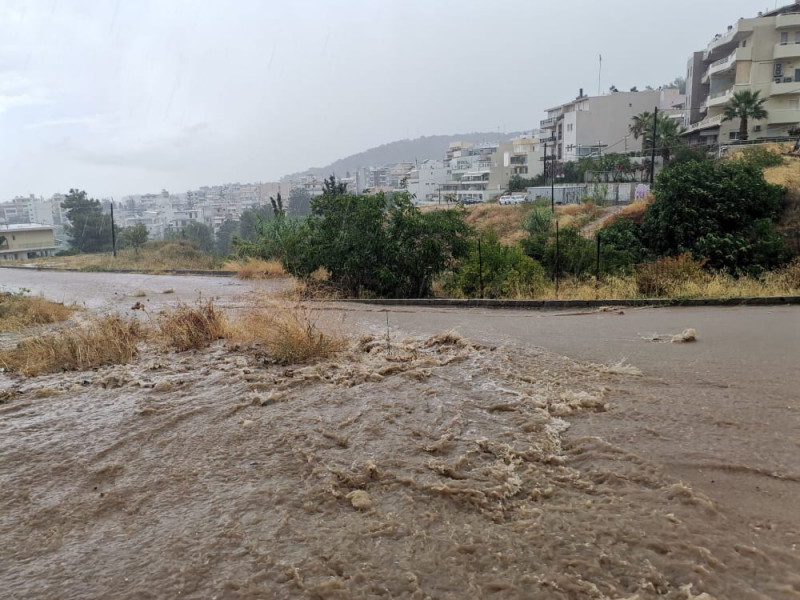
Strong storm in Rethymnon
A strong storm hit Rethymno in the afternoon, with the meteorologists being justified in their predictions and the intensity of the rain in just one hour, created problems both in the old town and in a large part of the residential fabric.
At the same time, there were power outages, which were soon restored. The main problem was related to the volume of water, which was not able to be absorbed by the rainwater drainage system, according to the president of the Rethymnon Trade Association, Athena Tsikintikou, who, speaking to APE-MPE, pointed out the need for better preparation everyone, citizens and services of the municipality and the sub-region.
The shopkeepers were forced to collect their goods from the sidewalks, while in the municipal garden, during the heavy storm, the officials were organizing the dismantling of the exhibition on Cretan food which ended last night. Many streets and in the city were flooded, while large amounts of soil created small mudflows in steeply sloping residential areas, mainly on the north side of the city.
According to information from the Fire Service, no problems were created other than a few pumpings of water from underground spaces and one cutting of a tree that was dangerous for passers-by.
View the news feed and get the latest news.
I have worked in the news industry for over 10 years. I have a vast amount of experience in covering health news. I am also an author at News Bulletin 247. I am highly experienced and knowledgeable in this field. I am a hard worker and always deliver quality work. I am a reliable source of information and always provide accurate information.


