

The fire started on August 19 and continues to burn until today – The areas of Giannouli and Sidiro were evacuated
The evolution of the fire in the Evros region is reflected in the satellite images of the burned areas as recorded by the Copernicus Rapid Mapping Service of the European Commissionfor the biggest forest fire of the last many years on European soil in Evro. The fire started on August 19 and continues to burn to this day, having active foci around the burned areas.
The following photo shows the evolution of the burned areas from the day the fire broke out until yesterday 29.08.2023. Continuing to burning for 12 days, the burned area in the last update by the Copernicus Rapid Mapping Service, amounted to 812,600 acres (until 29.08.2023, 12:03 local time). From the total burnt area of 812,600 acresthe approx 650,000 acres they burned the three days August 21-23.
See the evolution of the fire and the burned areas:
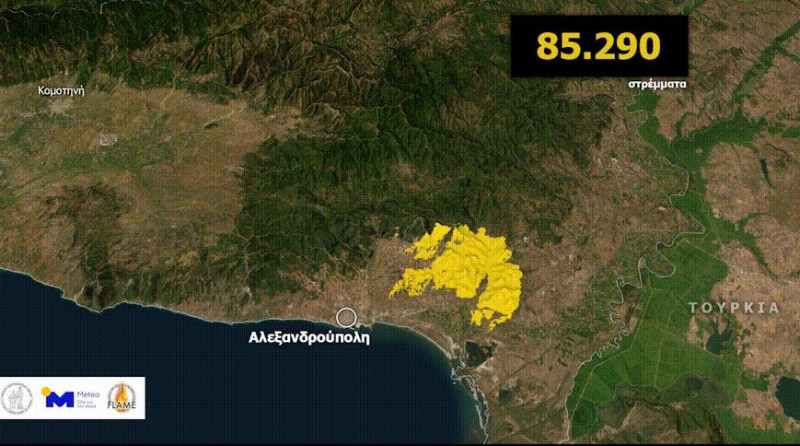
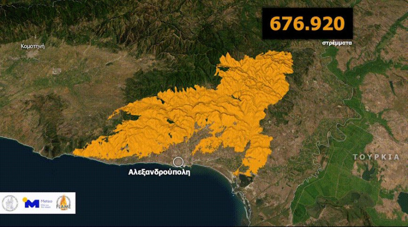
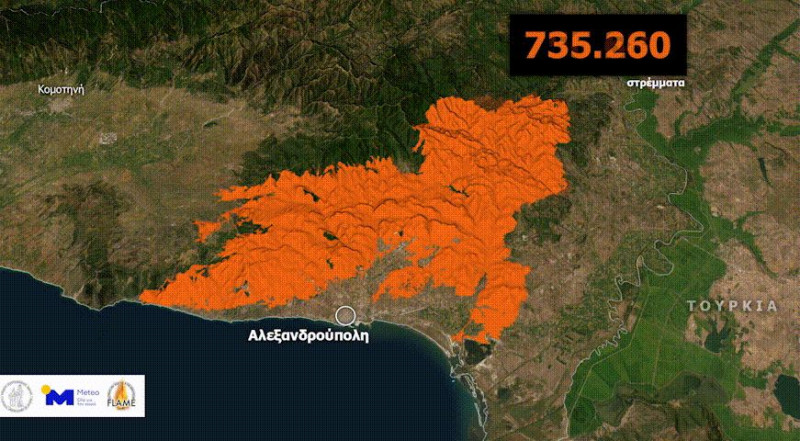
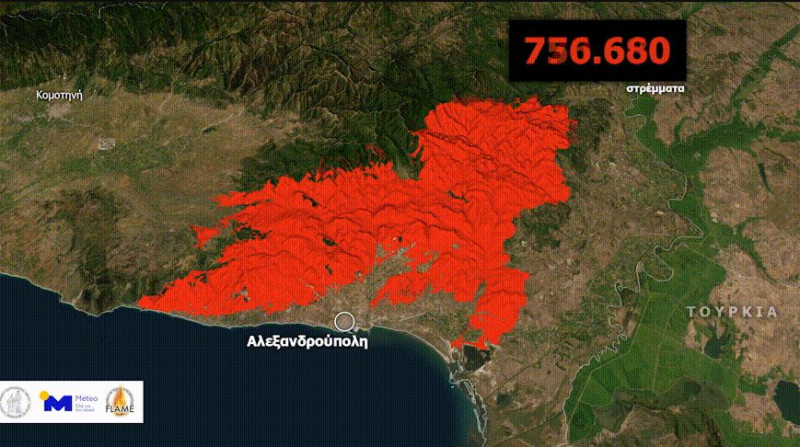
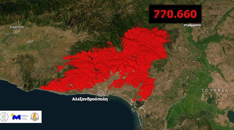
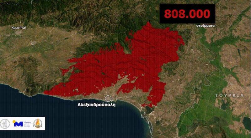
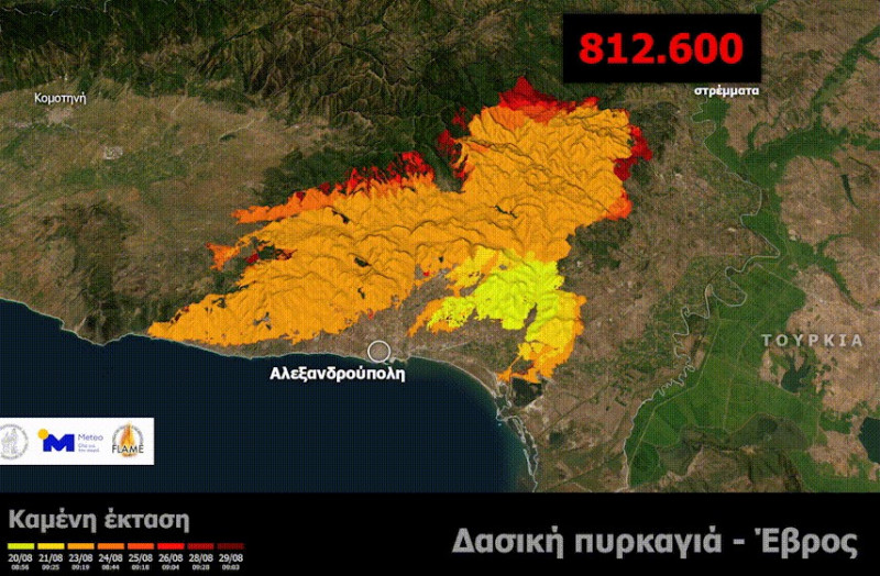
The visualization of the evolution of the burnt area in the big fire in Evrocarried out by its METEO unit National Observatory of Athens.
Message 112 for evacuation in the areas of Giannouli and Sidiro
An evacuation message from 112 was sent shortly before 3 in the afternoon to the residents and visitors of the Giannouli and Sidiro areas in Evros, where there are constantly outbreaks of fire.
Those who are in Sidiro are asked to move away towards Mega Dereion.
⚠️ Activation 1️⃣1️⃣2️⃣
🆘 If you are on #I iron move away towards #Mega_Derio
🔥 Forest fire in your area
‼️ Follow the instructions of the Authorities
ℹ️ https://t.co/kexUnlnGMV@pyrosvestiki@hellenicpolice
— 112 Greece (@112Greece) August 30, 2023
Those who are in the Giannouli area, must move towards Soufli.
⚠️ Activation 1️⃣1️⃣2️⃣
🆘 If you are in the area #Giannouli move away towards #Souffle
🔥 Forest fire in your area
‼️ Follow the instructions of the Authorities
ℹ️ https://t.co/kexUnlnGMV@pyrosvestiki@hellenicpolice
— 112 Greece (@112Greece) August 30, 2023
The two fire fronts are active in Leptokarya and Kotronia

The two major fronts of the fire in Evros that remain active are in the areas of Leptokarya and in particular in the location of Megalo Rema and in Kotronia.
Surrounding the settlement of Kotronia are large outbreaks of resurgence.
At 6.30 yesterday evening the area was evacuated with a message from 112, while since 5.30 in the morning the aerial means have been trying to limit the front.
The task of extinguishing, despite the strong firefighting forces -ground and air- which operate continuously in the area, in the last hours becomes even more difficult as the change in the direction of the winds to southerlies, from north-easters that were blowing against the flames in the previous days, today pushes the fire with its course seemingly uncontrollable.
It is noted that in the area 475 firefighters with 100 vehicles, 16 infantry units with the air support of 11 aircraft and five helicopters have been allocated for the extinguishing operations.
Videos and photos from Facebook e-evros.gr
Source: Skai
I have worked as a journalist for over 10 years, and my work has been featured on many different news websites. I am also an author, and my work has been published in several books. I specialize in opinion writing, and I often write about current events and controversial topics. I am a very well-rounded writer, and I have a lot of experience in different areas of journalism. I am a very hard worker, and I am always willing to put in the extra effort to get the job done.


