

Rains, thunderstorms and low temperature drop are coming from tomorrow until Thursday in our country.
An emergency bulletin of dangerous weather phenomena was issued earlier by the National Meteorological Service (EMY)
According to the forecast of SKAI meteorologist Christina Souzi, late tonight will rain in Western Greece that will gradually expand throughout the country.
The effects will be locally intense especially from noon on Tuesday in Western Greece and at night in Eastern Macedonia, Thrace and the islands of the eastern Aegean.
Also snow will fall in the mountains, the semi-mountains of Epirus, in Western Macedonia and at night in the mountains and semi-mountains of Eastern Macedonia and Thrace.
In Attica we will have intermittent rains mainly on Tuesday morning and afternoon while in Thessaloniki it will rain from noon onwards.
On Wednesday it will rain almost all over the country, while there will be thunderstorms that will be strong in places with snow in the central and northern mountains and northern semi-mountains. The effects at night will stop in the northwest but will continue in the east and south. The temperature will fall.
More specifically, according to EMY, the disturbance in the upper atmosphere coming from central Europe moves southeast and creates an upper and surface low in the Ionian, which within the next three days will move further east and affect the weather in our country, as described in the Extraordinary Bulletin. of the Weather (EDEK). There will be locally strong rains and thunderstorms mainly in the west, the central and northern parts of the country, as well as the Eastern Aegean, while snow will fall mainly in the mountains and semi-mountains of the central and northern mainland.
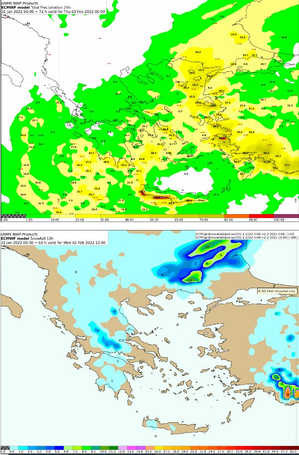
On Tuesday, rain and thunderstorms will occur from noon onwards in the Ionian Islands, Epirus and western Sterea, in the afternoon in the western Peloponnese and in the evening in eastern Macedonia, Thrace and the islands of the eastern Aegean. Snowfalls will occur in western Macedonia and in the mountainous-semi-mountainous areas of Epirus and gradually in central and eastern Macedonia and Thrace, while stormy south southwesterly winds will prevail in the seas, with an intensity of locally reaching 8 and possibly 9 beauforts. Below are the 24-hour rainfall maps, as well as the total amounts of 12-hour snowfall.
On Wednesday, the locally heavy rains and thunderstorms will continue, which will gradually extend from the morning hours in Thessaly, the Sporades, Evia, the eastern Sterea and temporarily in the eastern Peloponnese. From noon to afternoon the effects will extend to the Cyclades, Crete and the Dodecanese. The snowfall will be dense in places and will occur in the mountains of the mainland, in the semi-mountains of central and northern Greece, as well as in areas with lower altitudes of Thrace. Weakening of the phenomena is expected in the northern Ionian, Epirus and western Sterea at noon and in Thessaly, the Sporades and Evia at night. This can be seen very well in the total 12-hour snowfall from Wednesday noon onwards.
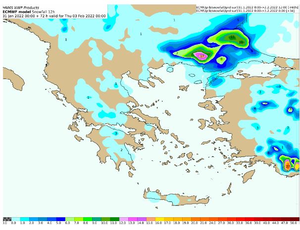
On Thursday, heavy rains and thunderstorms in places will occur in Crete, the Cyclades, the islands of the eastern Aegean and the Dodecanese and temporarily until noon in eastern Sterea and eastern Peloponnese. The effects will weaken initially in the islands of the eastern Aegean and gradually by nightfall in the rest of the regions. Heavy snowfall in places will occur in the mountains and semi-mountains of the central and northern country and in the morning and in areas of Thrace with lower altitudes.

The General Secretariat for Civil Protection (www.civilprotection.gr) of the Ministry of Climate Crisis & Civil Protection, has informed the competent state services involved, as well as the regions and municipalities of the country, in order to be on increased alert for civil protection, in order to deal immediately with the effects of severe weather.
At the same time, the General Secretariat for Civil Protection advises citizens to be especially careful, taking care to take measures to protect themselves from the dangers arising from the occurrence of severe weather phenomena.
In particular, in areas where heavy rainfall, storms or stormy winds are forecast:
Insure items that, if swept away by severe weather, could cause damage or injury.
Make sure that the gutters and gutters of the houses are not blocked and are operating normally.
Avoid crossing torrents and streams, on foot or by vehicle, during storms and rainfall, but also for several hours after the end of their event
Avoid field work and activities in the sea and coastal areas during severe weather events (risk of lightning strikes).
Take immediate precautions during a hailstorm. Take refuge in a building or car and do not leave the safe area until they are sure that the storm is over. Hail can also be very dangerous for animals.
Avoid passing under large trees, under hanging signs and generally in areas where light objects (eg pots, broken glass, etc.) can come off and fall to the ground (eg under balconies). .
To faithfully follow the instructions of the locally competent bodies, such as Traffic, etc.
Also, in areas where the occurrence of snow and frost is forecast:
If you are going to travel by car:
To be informed about the weather and the condition of the road network
Have anti-skid chains in their vehicle and the tank full of fuel
To travel, if necessary, preferably during the day, preferring the main roads
To inform their relatives about the route they are going to follow
Change their travel schedule to avoid the onslaught of the weather
To faithfully follow the instructions of the locally competent bodies, such as Traffic, etc.
If moving on foot:
Wear with multiple layers of light clothing instead of heavy clothing and wear appropriate footwear to avoid injuries due to slipperiness
Avoid unnecessary movements during peak phenomena (heavy snowfall, frost conditions)
For information and announcements regarding the prevailing situation and the passability of the road network due to the inflow of flood waters in it or due to snowfall and frost, the citizens can visit the website of EL.AS. www.astynomia.gr.
For more information and instructions for self-protection from severe weather conditions, citizens can visit the website of the General Secretariat for Civil Protection at www.civilprotection.gr.
Detailed weather forecast at skaikairos.gr
See all the news
Follow Skai.gr on Google News
and be the first to know all the news
Skai
I have worked in the news industry for over 10 years. I have a vast amount of experience in covering health news. I am also an author at News Bulletin 247. I am highly experienced and knowledgeable in this field. I am a hard worker and always deliver quality work. I am a reliable source of information and always provide accurate information.


