

Milliyet: “The Aegean midline choice. Half the Aegean will include the Turkish side” notes the Turkish newspaper Milliyet
Ankara plans for the “blue homeland”. The maritime spatial map is completed by Turkey, and will include half the Aegean in the context of the Erdoganian vision of the “Blue Homeland”.
“The blue homeland is deepened. Choice the midline of the Aegean. Half the Aegean will include the Turkish side ” The Turkish newspaper Milliyet notes in its headline, as reported by SKAI correspondent in Constantinople Manolis Kostidis.
Milliyet’s article in detail:
“Turkey has arrived at the stage of completing the Study of Marine Spatial Planning: Blue Homeland
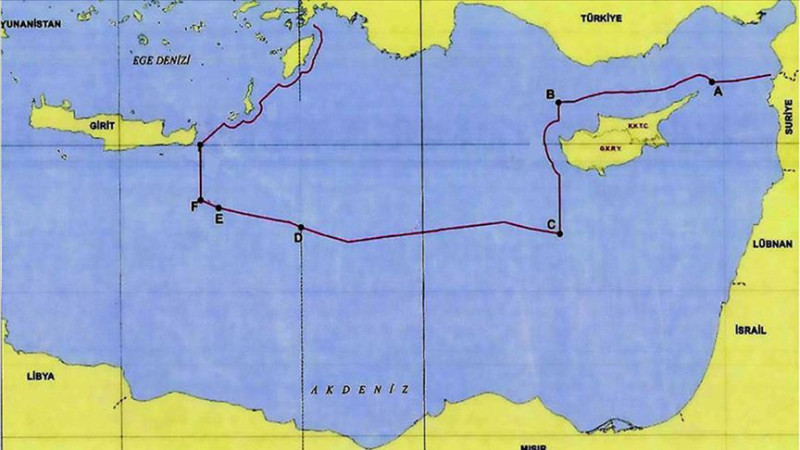
A scientific map of Turkey’s borders with Greece in the Aegean was prepared. In the Aegean Sea, where there are many differences between Greece and Turkey, the midline between the continental countries was taken as a border. It was reported that the map of the blue homeland is not a formal maritime jurisdiction that the state binds and is a scientific and legal study. The next step will be the TRNC and its spatial planning.
Turkey, which is closely monitoring EU spatial planning studies; is taking measures to protect its rights in the Aegean and the Mediterranean.
It became known that the Studies of Marine Spatial Planning (DMP) that Turkey began to protect its rights and interests in the surrounding seas,
To better evaluate the environmental impacts of its future seas and for the maximum use of marine areas, they have reached the final stage with the contribution of all relevant bodies.
The map, created by the National Maritime Law Research Center of the University of Ankara (Dehukam), was prepared according to the EU shipping.
The Director of the University of Ankara Dehukam, Dr. Mustafa Baskara, he told Milliyet: ‘If we look at the Mediterranean, it is compatible with the agreement we signed with’ TRNC ‘in 2011. Again, in the rest of the Eastern Mediterranean, whose coordinates were set to Libyan agreement in 2019, on our western border. The United Nations has been determined as the external borders’.
Source: Skai
I have worked in the news industry for over 10 years. I have been an author at News Bulletin 247 for the past 2 years. I mostly cover politics news. I am a highly experienced and respected journalist. I have won numerous awards for my work.


