

Floods again in Trikala, damage in Achaia – How will the phenomenon move in the next few hours
In western and southern Thessaly, Central Greece, north-northwestern Peloponnese and the Ionian Islands, the highest rainfall levels will be recorded today, due to the bad weather Elias that is affecting the country.
According to the updated severe weather bulletin, the Elias system will continue to affect parts of the country with heavy rain and thunderstorms, accompanied by hail and high frequency of lightning.
More detail:
Today is Tuesday (26-09-2023) local heavy rains and storms are predicted in the Ionian, the mainland (except Macedonia and Thrace), the Sporades and northern Evia. The highest levels of rain will be noted in Thessaly (in the prefectures of Karditsa, Trikala, Magnesia and the southern parts of the prefecture of Larissa), in Sterea (in the prefectures of Fthiotida, Evrytania and Fokida) and in Epirus (in the prefectures of Arta and Preveza).
Her Wednesday (27-09-2023) locally heavy rains and storms are predicted in the Ionian, the central and southern mainland (in Thessaly, Sterea and Peloponnese), in the Sporades, Evia, western Crete and possibly in the western Cyclades. It should be noted that the highest rainfall levels will occur in the prefectures of Karditsa, Fthiotida, in the eastern parts of the prefecture of Magnesia, in the Sporades and in northern Evia.
Her Thursday (28-09-2023) local heavy rains and storms are predicted until noon in the Sporades, Magnesia, northern Evia, and the northeastern parts of Sterea. Gradually the phenomena will weaken.
The residents of Xylokastro received a warning message from 112 yesterday evening, informing them of dangerous weather phenomena in their area.
Watch video:
Watch the course of the bad weather live:
They were asked to limit their movements during the phenomena and to follow the instructions of the authorities.
Heavy hail was recorded yesterday afternoon in areas of Corinthia, Achaia and Arcadia.
Many cars were damaged by the hail which fell at Kryoneri of Achaia. Problems also occurred in other areas of Kalavryta, such as Kleitoria.
In Thessaly, heavy rainfall occurred yesterday in the areas already affected by the previous bad weather.
Sta Trikalawithin just one hour, Kalambakas Street turned into a river with drivers stranded and looking for escape routes.
Strong phenomena occurred in the area of the Municipal Unit of Achelou, where there was a severe hailstorm lasting 10-15 minutes.
In the meantime, shortly before midnight, the flow to Athens of the Patras-Athens national road, through a detour in the opposite direction, from the Eleonas Toll Station at 163.5km, was given to traffic. up to 160.6 km, after the interruption due to mudslides.
Traffic was stopped shortly after the Eleonas toll road, due to landslides and mudslides caused by yesterday’s heavy rain in the area that had burned in the summer.
In a statement, Olympia Odos asks drivers traveling on the Patras – Athens highway to drive with caution and at low speeds and to comply with road markings.
Hail was recorded yesterday afternoon in areas of Corinth, Achaia and Arcadia, raising fears of damage to crops.
Many cars were damaged by the hail that fell in Kryoneri Achaia.
Problems also occurred in other areas of Kalavryta, such as Kleitoria.
Detailed weather forecast until Thursday
The Severe Weather Emergency Bulletin issued on (22/09) has been upgraded to a Hazardous Weather Emergency Bulletin according to the latest forecast. The severe weather system will bring heavy rain and thunderstorms accompanied by hail and high frequency of lightning.
This system was given the name Elias in accordance with WMO International Practice and EMY’s obligations to Eumetnet regarding the naming of severe weather.
On the rain map, the western parts of Thessaly can be seen, which are colored red, in accordance with what we have mentioned about the color thresholds applied by the EMY for the classification of bad weather.
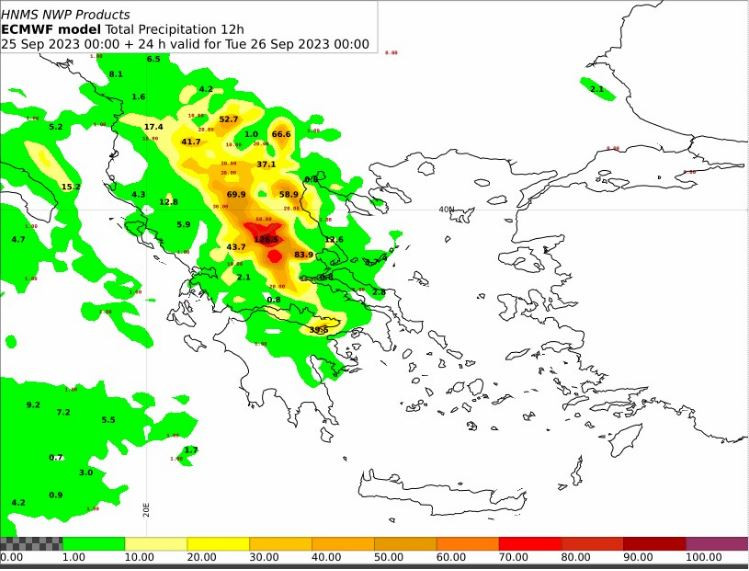
Map 1: 12-hour rainfall heights from Monday 12 to Tuesday 00 UTC. Source: EMY/ECMWF
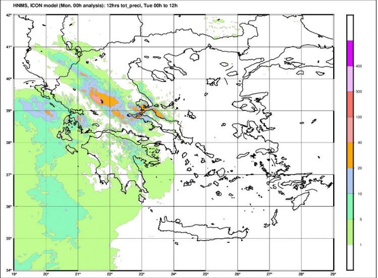
Map 2: 12-hour rainfall heights from Tuesday 00 to Tuesday 1200 UTC. Source: EMY/ ICON Model
The highest levels of rain will be noted: In Thessaly (in the prefectures of Karditsa, Trikala, Magnesia and the southern parts of the prefecture of Larissa), in Sterea (in the prefectures of Fthiotida, Evrytania and Viotia) and in Epirus in the prefectures of Arta and Preveza. (Map 2).
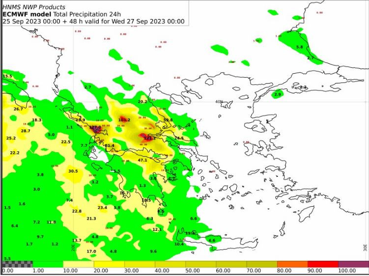
Map 3: 24-hour rainfall heights from Tuesday 00 to Wednesday 00 UTC. Source: EMY/ECMWF
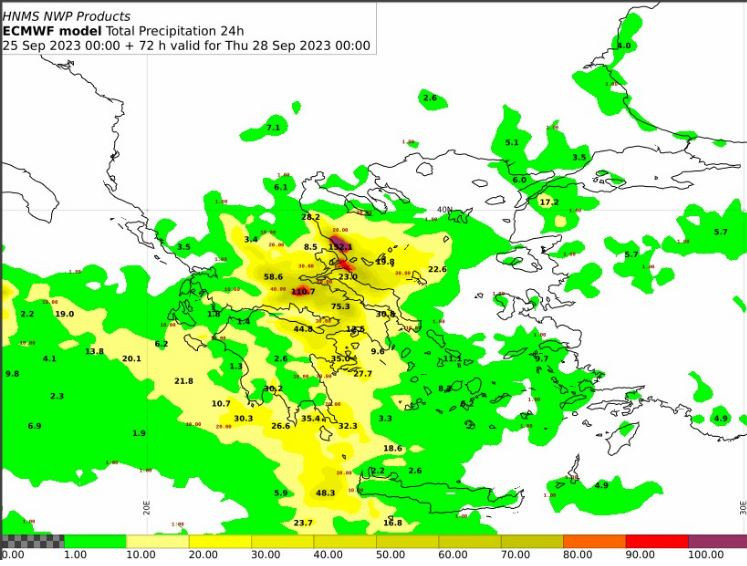
Map 4 : 24-hour rainfall heights from Wednesday 00 to Thursday 00 UTC Source: EMY/ECMWF
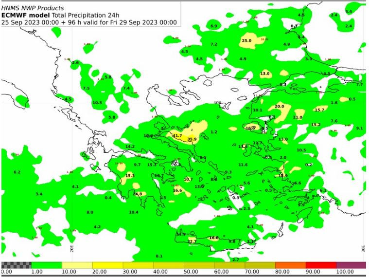
Map 5 : 24-hour rainfall heights from Thursday 00 to Friday 00 UTC Source: EMY/ECMWF
All the forces of the Fire Brigade, the Civil Protection, the Armed Forces and ELAS are on foot for the bad weather “Elias”
On foot are all the forces of the Fire Brigade, EMAK, Civil Protection, all the Armed Forces, the Greek Police together with the Region of Thessaly, volunteers and citizens
Video of heavy hail in Kalavryta – Major damage to crops
According to the SKAI correspondent Christos Stratoulakosthe crops in Kleitoria Kalavryta suffered great damage.
The heavy rainfall caused landslides in the area of the burnt lands.
Appreciated total amount of precipitation for the city of Patras 30-35mm.
Greater attention to political and flood protection issuesneeds the eastern part of Achaia (Aegialia-Aegira-Kalavryta), which, according to available evidence, appears to accept them higher precipitation heights with more intense phenomena.
The severity of the storm can also be seen from a video republished by the page on Facebook Weather News Greece from Meteo Hellas.
The following video is also indicative from the Tripoli Kalamata National Highway in the area of Asea (video source: Tasos Papadeas)
Hail and landslides in Karditsa
From early Monday afternoon, the bad weather “Elias” began to affect Karditsastarting from the massif.
The Mayor of Argitheas, Andreas Stergiou, reported to karditsalive.net that more intense phenomena were initially manifested in the area of the Municipal Unit of Achelou, where there was severe hailstorm lasting 10-15 minutes, while heavy rains are currently occurring throughout the entire area of the Municipality.
With the onset of bad weather, the first minor problems occurred, mainly landslides and collapses in some parts of the road network with the most important on the road Petrotos – Kali Komi.
There are reports of heavy rainfall from the mountainous and semi-mountainous communities and the Municipalities of Mouzaki and Limni Plastira, phenomena that extend to the plains now where in the evening and tomorrow Tuesday the bulk of the rainfall is expected. It is noted that within about an hour, the meteorological station of Pezoula recorded 25 mm of rain.
Within an hour, Kalambakas Street turned into a river in Trikala – Video – Photo
Kalambakas Street turned into a river in the first hour of the Elias storm in Trikala.
In particular, as stated by trikalavoice.gr Kalambakas street from the height of “SKLAVENITI” and below has turned into a lake (third time in 4 months) and drivers were trapped, looking for escape routes.
Recommendations of Civil Protection
The General Secretariat of Civil Protection (civilprotection.gov.gr) of the Ministry of Climate Crisis & Civil Protection, has informed the competent government agencies involved, as well as the regions and municipalities of the country, so that they are on increased civil protection readiness, in order to face directly the effects of the occurrence of intense weather phenomena.
At the same time, the General Secretariat of Civil Protection recommends that citizens be particularly careful, taking measures to protect themselves from risks arising from the occurrence of severe weather phenomena.
In particular, in areas where heavy rainfall, storms or gale-force winds are expected to occur:
- To secure objects which, if carried away by severe weather conditions, may cause damage or injury.
- Make sure that the gutters and downspouts of the houses are not blocked and are working properly.
- Avoid crossing torrents and streams, on foot or by vehicle, during storms and rainfall, but also for several hours after the end of their event
- Avoid outdoor work and activities in marine and coastal areas during severe weather events (risk of lightning strikes).
- Take shelter immediately during a hailstorm. Take shelter in a building or car and do not leave the safe area until they are sure the storm has passed. Hail can be very dangerous for animals too.
- Avoid passing under large trees, under posted signs and in general areas where light objects (e.g. pots, broken glass, etc.) can become detached and fall to the ground (e.g. under balconies) .
- To faithfully follow the instructions of the local authorities, such as Traffic, etc.
In areas with intense lightning activity:
If you are at home
- Avoid touching plumbing pipes (kitchen, bathroom) as they are good conductors of electricity.
If you are in the car
- Park it on the side of the road and away from trees that might fall on it.
- Stay inside and turn on your stop warning lights (emergency lights) until the storm clears.
- Close windows and do not touch metal objects.
- Avoid flooded roads.
If you are outdoors
- Take refuge in a building or car or sit on the ground immediately without lying down.
- Take cover under solid branches of low trees if you are in the woods.
- Never take shelter under a tall tree in an open area.
- Avoid low-lying lands for the risk of flooding.
- Do not stand next to utility poles, power lines, telephone lines and fences.
- Do not approach metal objects (eg cars, bicycles, camping equipment, etc.).
- Stay away from rivers, lakes or other bodies of water.
If you are in the sea, get out immediately.
If you’re isolated on a flat surface and feel your hair stand on end (signaling that lightning is about to strike), sit deep with your head between your legs (to minimize your body surface area and contact with the ground ) by throwing the metal objects you have on you.
For information and announcements regarding the prevailing situation and the passability of the road network due to the influx of flood waters into it, citizens can visit the EL.AS website. www.astynomia.gr.
For more information and self-protection instructions from severe weather, citizens can visit the website of the General Secretariat of Civil Protection at civilprotection.gov.gr
Source: Skai
I have worked as a journalist for over 10 years, and my work has been featured on many different news websites. I am also an author, and my work has been published in several books. I specialize in opinion writing, and I often write about current events and controversial topics. I am a very well-rounded writer, and I have a lot of experience in different areas of journalism. I am a very hard worker, and I am always willing to put in the extra effort to get the job done.


