

The weather in our country is deteriorating from noon on Tuesday (01-02-2022) to Thursday (03-02-2022), with main characteristics of rains and storms, snowfall mainly in the central and northern mountains – semi-mountains and stormy winds of 8 and locally up to 9 Beaufort in the seas.
Cloudy skies with local rain and sporadic thunderstorms are forecast in most parts of the country. The effects will be strong in places from noon on the Ionian islands, Epirus and western Sterea and from the evening in eastern Macedonia, Thrace and the islands of the eastern Aegean. Snowfalls will occur in the mainland mountains, in places dense in western Macedonia, in the mountainous – semi-mountainous areas of Epirus and gradually in central and eastern Macedonia and Thrace.
The winds will blow south southwest 5 to 7 and in the seas locally 8 beaufort.
The temperature will drop slightly in the northwest while in the other areas it will not change significantly. In the northern continents it will reach 10 to 13 degrees and in the rest of the country 14 to 17 degrees Celsius.
Frost will occur in places in the northwest in the morning and evening.
More specifically, according to EMY, the disturbance in the upper atmosphere coming from central Europe moves southeast and creates an upper and surface low in the Ionian, which will move further east and affect the weather in our country, as described in the Extraordinary Weather Bulletin (EDE). ). There will be locally strong rains and thunderstorms mainly in the west, the central and northern parts of the country, as well as the Eastern Aegean, while snow will fall mainly in the mountains and semi-mountains of the central and northern mainland.
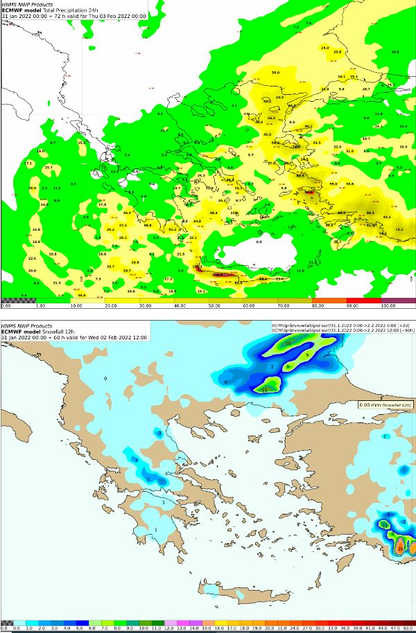
On Tuesday, rain and thunderstorms will occur from noon onwards in the Ionian Islands, Epirus and western Sterea, in the afternoon in the western Peloponnese and in the evening in eastern Macedonia, Thrace and the islands of the eastern Aegean. Snowfalls will occur in western Macedonia and in the mountainous-semi-mountainous areas of Epirus and gradually in central and eastern Macedonia and Thrace, while stormy south southwesterly winds will prevail in the seas, with an intensity of locally reaching 8 and possibly 9 beauforts. Below are the 24-hour rainfall maps, as well as the total 12-hour snowfall amounts.
On Wednesday, the locally heavy rains and thunderstorms will continue, which will gradually extend from the morning hours in Thessaly, the Sporades, Evia, the eastern Sterea and temporarily in the eastern Peloponnese. From noon to afternoon the effects will extend to the Cyclades, Crete and the Dodecanese. The snowfall will be dense in places and will occur in the mountains of the mainland, in the semi-mountains of central and northern Greece, as well as in areas with lower altitudes of Thrace. Weakening of the phenomena is expected in the northern Ionian, Epirus and western Sterea at noon and in Thessaly, the Sporades and Evia at night. This can be seen very well in the total 12-hour snowfall from Wednesday noon onwards.
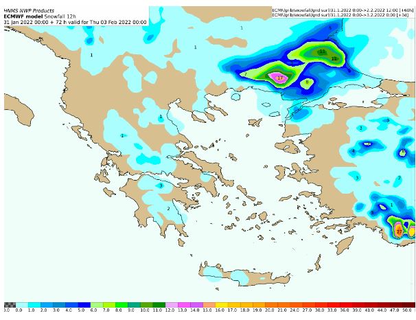
On Thursday, heavy rains and thunderstorms in places will occur in Crete, the Cyclades, the islands of the eastern Aegean and the Dodecanese and temporarily until noon in eastern Sterea and eastern Peloponnese. The effects will weaken initially in the islands of the eastern Aegean and gradually by nightfall in the rest of the regions. Heavy snowfall in places will occur in the mountains and semi-mountains of the central and northern country and in the morning and in areas of Thrace with lower altitudes.

MACEDONIA, THRACE
Weather: Cloudy with rain or sleet and sporadic thunderstorms. The phenomena from the night in eastern Macedonia and Thrace will be strong in places. Heavy snowfalls in places will occur in western Macedonia and gradually in the mountains – semi-mountains of central and eastern Macedonia and Thrace.
Winds: From south 4 to 6 and in the Thracian locally 7 Beaufort. In Macedonia they will quickly turn to north directions 4 to 5 and at night up to 6 Beaufort.
Temperature: From 00 (zero) to 13 degrees Celsius. In western Macedonia 2 to 3 points lower.
IONIAN ISLANDS, EPIRUS, WESTERN STEREA, WESTERN PELOPONNESE
Weather: Cloudy with local rains and sporadic thunderstorms. The effects from noon will be strong in places in the Ionian, Epirus and western Sterea and from the afternoon in the western Peloponnese. Snowfalls will occur in the mainland mountains as well as in the semi-mountains of Epirus where they will be dense in places.
Winds: From south 5 to 7 and in the southern Ionian locally 8 beauforts.
Temperature: From 02 to 15 degrees Celsius. In the interior of Epirus 3 to 4 degrees lower.
THESSALY, EASTERN CENTRAL, EASTERN PELOPONNESE
Weather: Cloudy skies temporarily increased with local rains and sporadic thunderstorms from noon. Snowfalls will occur from noon in the mountains, mainly in Thessaly and Sterea.
Winds: South southwest 6 to 7 and in the south local 8 Beaufort. From noon to north they will turn to north northwest 4 to 5 and in the evening 6 locally 7 beauforts.
Temperature: From 02 to 17 degrees Celsius. In the north 3 to 4 degrees lower.
CYCLADES, CRETE
Weather: Cloudy skies temporarily increased with local rains and from the afternoon isolated thunderstorms.
Winds: South southwest 6 to 7 and locally 8 Beaufort.
Temperature: From 10 to 17 degrees Celsius.
EASTERN AEGEAN ISLANDS – DODECANESE
Weather: Cloudy skies with local rains and gradual sporadic thunderstorms which in the islands of the eastern Aegean from the night will be strong in places.
Winds: South southwest 6 to 7 and locally 8 Beaufort.
Temperature: From 08 to 16 degrees Celsius. In the north 3 to 4 degrees lower.
EUBOEA
Weather: Cloudy skies temporarily increased with local rains and sporadic thunderstorms from noon.
Winds: South southwest 5 to 6 and in the south local 7 Beaufort.
Temperature: From 03 to 14 degrees Celsius.
ATTICA
Weather: Cloudy skies temporarily increased with local rains and isolated thunderstorms from noon.
Winds: South southwest 6 to 7 Beaufort.
Temperature: From 10 to 15 degrees Celsius.
THESSALONIKI
Weather: Cloudy with local rains and sporadic thunderstorms from noon.
Winds: Northwest 3 to 4 which from the afternoon will strengthen to 6 to 7 Beaufort.
Temperature: From 05 to 12 degrees Celsius.
FORECAST FOR TOMORROW WEDNESDAY 02-02-2022
Increased clouds with rain and sporadic thunderstorms in places strong in western Greece, eastern Macedonia, Thrace, the islands of the eastern Aegean, in the eastern mainland, the Sporades, Evia and gradually from noon in the Cyclades are forecast throughout the country. Crete and the Dodecanese. Heavy snowfall in places will occur in the mountains, semi-mountains of the central and northern country, as well as in areas of Thrace with lower altitudes. The phenomena at noon in the northern Ionian, Epirus and western Sterea and at night in Thessaly, the Sporades and Evia are expected to weaken.
The winds will blow in the east and south, south southwest 5 to 7 and in the Aegean locally 8 beauforts and in the other areas from north directions 4 to 6 beauforts, gradually strengthening to 5 to 7 and in the Ionian up to 8 beauforts.
The temperature will drop in the west, central and north and will not exceed 6 to 8 degrees in Macedonia, Thrace and Thessaly, in the rest of the mainland and the Ionian islands 13 to 14 degrees, while in the Aegean islands. will reach 15 to 16 degrees Celsius. Frost will occur in the morning and evening in places in the central and northern continents.
Detailed weather forecast at skaikairos.gr
See all the news
Follow Skai.gr on Google News
and be the first to know all the news
Skai
I have worked in the news industry for over 10 years. I have a vast amount of experience in covering health news. I am also an author at News Bulletin 247. I am highly experienced and knowledgeable in this field. I am a hard worker and always deliver quality work. I am a reliable source of information and always provide accurate information.


