

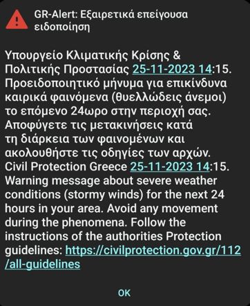
The message states that dangerous weather conditions are expected in the area for the next twelve hours and calls for movement restrictions
Citizens in Attica also received a warning message about dangerous weather phenomena a while ago.
The message states that dangerous weather phenomena are expected in the area for the next twelve hours and calls for restrictions on movement.
“Warning message for hazardous weather (gale force winds) for the next 12 hours in your area. Limit your movements to the absolutely necessary and follow the instructions of the authorities”, he says characteristically.
Warning message from “112” for dangerous weather phenomena was sent earlier to the mobile phones of the residents of Achaia.
In particular, it states that in the next 24 hours stormy winds are predicted in the areas of the Patraikos and Corinthian Gulfs.
At the same time, residents are advised to avoid traveling during the phenomena.
Residents of Thessaloniki and Patras received a notification from the General Secretariat of Civil Protection at noon on Saturday, due to the dangerous weather phenomena that are expected to occur in the area in the next few hours.
“Avoid traveling during the phenomena and follow the instructions of the authorities,” he wrote characteristically.
“Kampanaki” rang 112 for the Cyclades and the northern Aegean, warning citizens of dangerous weather phenomena (stormy winds) in the next 24 hours in their area and calling on them to avoid traveling during the phenomena.
Specifically, the message states: “Warning message for dangerous weather phenomena (stormy winds) in the next 24 hours in your area. Avoid traveling during the phenomena and follow the instructions of the Authorities”.
Messages from 112 were sent indicatively to Naxos to warn of dangerous weather phenomena.
“Avoid traveling during the dangerous phenomena” says the notice.

Emergency Weather Deterioration Bulletin
The Emergency Weather Deterioration Bulletin issued on 11-24-2023/1200 is updated according to the latest forecast data in the Emergency Bulletin of Dangerous Weather Phenomena, due to the significant and rapid deepening of the barometric low Bettina that formed in the Adriatic and is moving towards our country, resulting in the significant strengthening of winds that will reach 9 and possibly locally in 10 Beaufort.
More specifically:
Bad weather is expected over the weekend (25-11-23 and 26-11-23), with the main features being very gusty winds across almost the entire country and locally heavy rain and storms mainly in the west, north and east and south island Hellas.
Snowfall will occur in the continental highlands but also in semi-mountainous areas of Thrace, Macedonia and temporarily in Epirus.
The temperature will drop significantly from Saturday night and especially on Sunday, when it will drop by 8 to 10 degrees in the Ionian and continental regions and by 4 to 6 degrees Celsius in the rest of the regions.
More detail:
A. Very gale force winds are expected:
a. in the west by early afternoon saturday, initially west southwest 7 to 8 and quickly northwest 8 to 9 and possibly locally in the Ionian to 10 Beaufort.
b. in the east from Saturday afternoon southwest 7 to 9, with gusts possibly reaching 10 Beaufort. Gradually from the evening they will turn to northwesterlies up to 9 Beaufort.
c. weakening of the winds is predicted from Sunday afternoon.
B. Heavy rains and storms are forecast today Saturday:
a. in the Ionian, Epirus, western Sterea, western Peloponnese, the Dodecanese, the islands of the eastern Aegean, eastern Macedonia and Thrace.
b. temporarily the rest of Macedonia, the rest of Peloponnese, the western and southern main parts of Crete, western Thessaly and central Sterea will be affected.
c. the strong phenomena on Saturday night will be limited to eastern Macedonia, Thrace and eastern island Greece, while in the rest of the country they will weaken.
C. Snowfall will occur from the evening hours of Saturday until the midday hours of Sunday in the continental highlands, in semi-mountainous areas of Thrace, Macedonia and temporarily in Epirus with an indicative altitude of 500-700 meters and possibly locally in areas with a lower altitude of eastern Macedonia and Thrace.
More details on the development of the weather in the regular and extraordinary weather bulletins, on the EMY website (www.emy.gr). Forecasts will be updated every twelve hours.
Source: Skai
I have worked as a journalist for over 10 years, and my work has been featured on many different news websites. I am also an author, and my work has been published in several books. I specialize in opinion writing, and I often write about current events and controversial topics. I am a very well-rounded writer, and I have a lot of experience in different areas of journalism. I am a very hard worker, and I am always willing to put in the extra effort to get the job done.


