

Detailed weather forecast until Saturday – The recommendations of Civil Protection – Earlier a message via 112 was sent to residents of Thessaly, areas of Central Macedonia, Central Greece, Northern Aegean islands – Roads in Pelion are flooded
The Authorities are on alert in view of the bad weather that is expected to hit our country and especially 4 regions. A barometric low accompanied by fronts is forecast to cause worsening weather in most of the country, from early this afternoon until tomorrow Saturday (20-04-24) at noon, with heavy rain and thunderstorms.
Watch the course of the bad weather live:
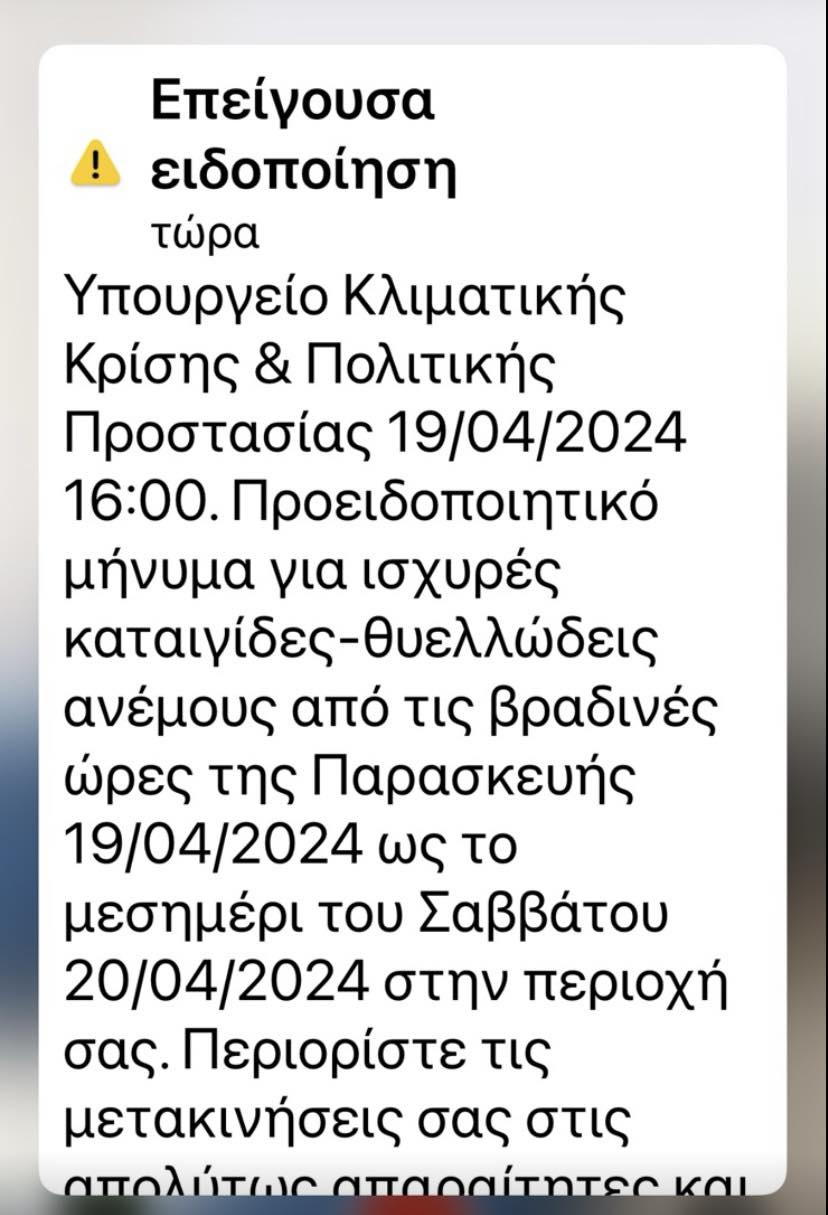
Message via 112was sent to its inhabitants Thessaly, regions of Central Macedonia, Central Greece, Northern Aegean islands warning them of severe thunderstorms from the evening hours of Friday 04/19/2024 until noon on Saturday 04/20/2024 in their area.
Citizens are asked to limit movements during the phenomena to those absolutely necessary.
📍#Thessaly regions #Central Macedonia #Mainland Greece #northern_Aegean_island
🆘 Warning message for severe storms-gale force winds from the evening hours of Friday 04/19/2024 until noon on Saturday 04/20/2024 in your area
‼️ Limit the…
— 112 Greece (@112Greece) April 19, 2024
A 112 message was sent at 4 pm and to the residents of Volos and the wider area of Magnesia by the Ministry of Climate Crisis and Civil Protection due to the bad weather that is expected to pass through the area late this afternoon until noon on Saturday.
Specifically, the 112 message informs the population that this is a “Warning message for strong storms – gale force winds from the evening hours of Friday 19/04/2024 to noon on Saturday 20/04/2024 in your area. Limit your movements to the absolutely necessary and follow the instructions of the Authorities”.
Kikilias on bad weather: “We are all here together on vigilance”
“We have to deal with a phenomenon. It is certainly not of the order of the phenomena we faced in the previous months. But it is in a burdened and troubled field” said the Minister of Civil Protection Vassilis Kikilias after the end of the meeting held today in the Region of Thessaly regarding the weather phenomena.
Mr. Kikilias said, among other things, that he has requested that the relevant services be dispersed throughout the night and that there be monitoring per region of Thessaly and beyond.
“Vigilance must be everywhere. As you also read on 112, it would be good for these evening hours when the meteorologists say that the phenomenon will be at a greater intensity, to limit our movements” said the minister at the same time and added: “It is important that we work on the part of prevention all together. It is important that we work and operate for the part of prevention all together. It is an effort that concerns everyone in an organized system which must slowly see its automations and operate in an organized and structured manner.”
He further stated:
“The Risk Assessment Committee was convened again this morning which partially upgraded the bad weather that will pass through our country in the next few hours and based on these data, for precautionary reasons, I am leaving for Thessaly where at 3 o’clock in the afternoon become coordinating, where the Police, Fire, Army and Local Government forces have been deployed anyway.
Our meteorologists and the Risk Assessment Committee are talking about a bad weather that will mainly affect, this afternoon – evening hours and until dawn, Thessaly – I am going there as the area is burdened, as is the field there, so I have to to exercise due care – Pieria, North Evia, the Sporades, the Northeast Aegean and perhaps a part of Halkidiki. It will, of course, also pass through other areas.
I repeat: of short duration than it seems, with a volume of rain of about 90mm in 12 hours or in total from what I see 120mm in 24 hours. Based on the damaged infrastructures and the problems in Thessaly since the previous major disaster, we have already moved in the last 24 hours and the entire state apparatus must be ready there as well. Thank you.”
For his part, the governor of Thessaly Dimitris Kouretas emphasized that all services of the Region are on alert.
The meeting was attended by all the involved mayors of the prefecture as well as representatives from the Police, the Army and the Fire Department.
Evening schools are closed
Following a recommendation from the Regional Directorate of Education B. Ziakas, the Regional Governor of Thessaly D. Kouretas decided for today, Friday, April 19, 2024, the suspension of the operation of all Vesper school units in the Region of Thessaly due to impending severe weather conditions.
The emergency bulletin from the EMY
The EMY has issued an emergency notice of dangerous weather phenomenaupdating the previous severe Weather Advisory.
Based on the forecasts, the phenomena from the evening hours today Friday to the early afternoon hours tomorrow Saturday will be particularly intense and present a greater risk in Eastern Thessaly, Sporades (mainly Skiathos and Skopelos), Southern Pieria, Northern Evia, Prefecture of Fthiotida (in the north ), Eastern Aegean Islands (mainly Chios and Lesbos).
In particular, as reported by the EMY, a barometric low accompanied by fronts is predicted to cause a worsening of the weather in most of the country, from today Friday (19-04-24) in the early afternoon until tomorrow Saturday (20-04-24) at noon, with heavy rains and storms.
The intense phenomena will start from the west, will quickly spread to the central and northern continents, the Sporades, Evia, the Cyclades, the eastern Aegean and later the Dodecanese.
Local hailstorms are expected to occur mainly in the eastern Aegean.
The winds will be strong and will reach 7 and locally 8 Beaufort.
More detail:
A. Heavy rains and storms are forecast:
Today Friday (19-04-24)
a. From early afternoon to the Ionian Islands, Epirus and western Sterea.
b. From late afternoon in Thessaly, western Macedonia, western Peloponnese and the northern parts of eastern Sterea (Fthiotida).
c. In the evening hours the phenomena will extend further east and will affect areas of central and eastern Macedonia
(mainly the prefecture of Pieria, the prefecture of Halkidiki as well as the sea-coastal areas of the prefecture of Serres and the prefecture of Kavala), the Sporades, Evia
(mainly the northern parts), the Cyclades, Thrace and the islands of the eastern Aegean.
d. A gradual weakening of the phenomena is expected from the evening hours in the Ionian and the western continents.
Saturday (20-04-24)
Until midday hours in Thessaly (mainly in Magnesia and the eastern parts of Larissa), the Sporades,
Evia (mainly the northern parts), in areas of central and eastern Macedonia (mainly the province of Pieria,
Chalkidiki prefecture as well as the sea-coastal areas of Serres prefecture and Kavala prefecture), Thrace (mainly the southern and eastern parts),
the islands of the eastern Aegean and the Dodecanese.
B. The phenomena from the evening hours today Friday (19-04-24) to the morning hours tomorrow Saturday (20-04-24) will be particularly intense and present a greater risk in the following areas:
- Eastern Thessaly
- Sporades (mainly Skiathos and Skopelos)
- South Pieria
- Northern Evia
- Prefecture of Fthiotida (in the north)
- Eastern Aegean islands (mainly Chios and Lesbos)
According to the EMY, the emergency bulletins will be updated every twelve hours.
Recommendations of Civil Protection
The General Secretariat of Civil Protection (civilprotection.gov.gr) of the Ministry of Climate Crisis & Civil Protection, has informed the competent government agencies involved, as well as the regions and municipalities of the country, so that they are on increased civil protection readiness, in order to face directly the effects of the occurrence of intense weather phenomena.
At the same time, the General Secretariat of Civil Protection recommends that citizens be particularly careful, taking measures to protect themselves from risks arising from the occurrence of severe weather phenomena.
In particular, in areas where heavy rainfall, storms or gale-force winds are expected to occur:
- To secure objects which, if carried away by severe weather conditions, may cause damage or injury.
- Make sure that the gutters and downspouts of the houses are not blocked and are working properly.
- Avoid crossing torrents and streams, on foot or by vehicle, during storms and rainfall, but also for several hours after the end of their event
- Avoid outdoor work and activities in marine and coastal areas during severe weather events (risk of lightning strikes).
- Take shelter immediately during a hailstorm. Take shelter in a building or car and do not leave the safe area until they are sure the storm has passed. Hail can be very dangerous for animals too.
- Avoid passing under large trees, under posted signs and in general areas where light objects (e.g. pots, broken glass, etc.) can become detached and fall to the ground (e.g. under balconies) .
- To faithfully follow the instructions of the local authorities, such as Traffic, etc.
In areas with intense lightning activity:
If you are at home
- Do not hold electrical appliances or the telephone as lightning can pass through the wires. Disconnect the TV sets from the antenna and the power supply.
- Avoid touching plumbing pipes (kitchen, bathroom) as they are good conductors of electricity.
If you are in the car
- Park it on the side of the road and away from trees that might fall on it.
- Stay inside and turn on your stop warning lights (emergency lights) until the storm clears.
- Close windows and do not touch metal objects.
- Avoid flooded roads.
If you are outdoors
- Take refuge in a building or car or sit on the ground immediately without lying down.
- Take cover under solid branches of low trees if you are in a forest.
- Never take shelter under a tall tree in an open area.
- Avoid low-lying lands for the risk of flooding.
- Do not stand next to utility poles, power lines, telephone lines and fences.
- Do not approach metal objects (eg cars, bicycles, camping equipment, etc.).
- Stay away from rivers, lakes or other bodies of water.
- If you are in the sea, get out immediately.
- If you’re isolated on a flat surface and feel your hair stand on end (signaling that lightning is about to strike), sit deep with your head between your legs (to minimize your body surface area and contact with the ground ) by throwing the metal objects you have on you.
For information and announcements regarding the prevailing situation and the passability of the road network due to the inflow of flood waters, citizens can visit the EL.AS website. www.astynomia.gr.
For more information and self-protection instructions from severe weather, citizens can visit the website of the General Secretariat of Civil Protection at civilprotection.gov.gr
Source: Skai
I have worked as a journalist for over 10 years, and my work has been featured on many different news websites. I am also an author, and my work has been published in several books. I specialize in opinion writing, and I often write about current events and controversial topics. I am a very well-rounded writer, and I have a lot of experience in different areas of journalism. I am a very hard worker, and I am always willing to put in the extra effort to get the job done.


