

The main reason for this change in weather – Civil Protection on alert – Detailed weather forecast until Wednesday
From this evening, the bad weather Atena is expected to be felt in our country, which will last until the evening hours of Wednesday, according to the emergency worsening weather bulletin from the National Weather Service, which was upgraded to an Emergency Bulletin of Dangerous Weather Phenomena according to the newer prognostic evidence.
Warning message 112 to residents of its areas Western Greece and her Peloponnese sent at 6pm.
The message warns residents of impending hazardous weather until noon Tuesday (10/9).
Watch the course of the bad weather live:
According to meteo.gr/National Observatory of Athens, the main reason for this change in weather is the change in the atmospheric circulation over Europe as well as the position of the air current (purple shades in Figure 1) over the Mediterranean which has contributed in the development of a barometric low over the area of Italy (Figure 1). We remind you that the air current is a strong current of air at a height of about 10-11 kilometers from the surface of the earth with a basic movement from west to east and its movement determines the creation and movement of barometric systems. The east-southeast movement of the barometric low from the area of Italy towards the Southern Balkans and our country during Monday 09/09 will result in a gradual change of weather from the west of our country with rain and storms.
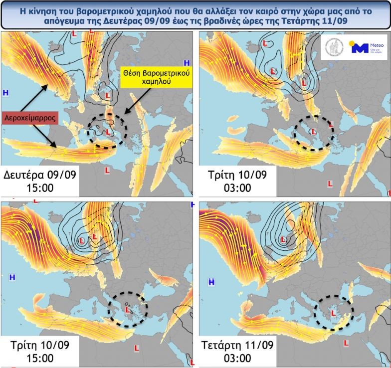
Figure 1: The movement of the barometric low that will change the weather in our country from the afternoon of Monday 09/09 to the evening hours of Wednesday 11/09. With orange shades the position of the air dam can be distinguished.
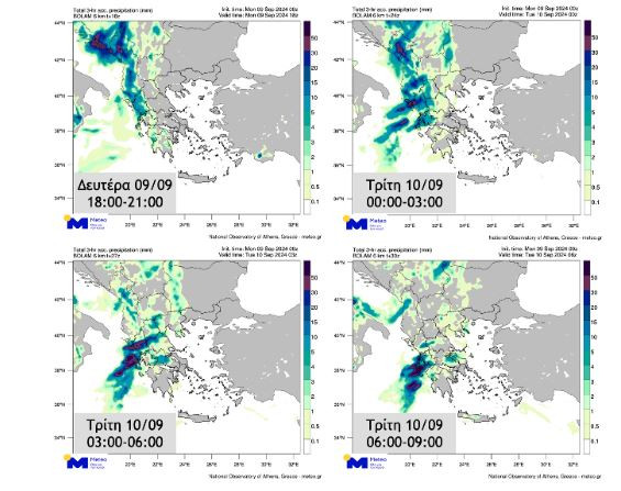
According to the five-level categorization of a rainfall episode (Regional Precipitation Index), which is applied by the METEO unit of the National Observatory of Athens, the rainfall episode is classified as Category 3 (Significant).
The set of forecast maps below shows the estimated 3 hour cumulative rainfall between 18:00-21:00 Monday 09/09, 00:00-03:00, 03:00-06:00 and 06:00-09:00 Tuesday 10/09.
Civil Protection on alert – Kikilias: The “ATENA” bad weather will last longer, flooding is not excluded
The scientific met Risk Assessment Committee and an inter-ministerial meeting was convened under the Minister of Climate Crisis and Civil Protection, Vassilis Kikilia, in view of the dangerous weather phenomena expected in the country.
As the minister stated, “based on the extensive briefing of the Risk Assessment Committee and according to the EMY bulletin, from tonight evening and for the next few days there will be hazardous weather phenomena in many areas of the country”, while pointing out that “this is not a summer instability, but an autumn system”. “Practically, this means that the bad weather will last longer, so local flooding is not ruled out”, underlined Mr. Kikilias.
Specifically, Mr. Kikilias stated:
“Based on the extensive information provided by the Risk Assessment Committee and according to the EMY bulletin, dangerous weather phenomena will occur in many areas of the country starting tonight and for the next few days.
This is not a summer instability, but an autumn system. In practice, this means that the bad weather will last longer, so local flooding is not excluded.
More specifically, from this evening until the early hours of the morning, large amounts of rain will occur mainly in the Ionian, while Epirus, the Western Mainland and the Western Peloponnese will also be affected.
Also, tomorrow from the early hours of the morning until the afternoon, the bad weather will affect Western and Central Macedonia, as well as Northern and Western Thessaly.
An inter-ministerial committee meeting has already been convened with the participation of all the involved bodies, i.e. the security forces and the armed forces, the local government, the concessionaire highways, etc. for the preparation and coordination of the state mechanism”.
Emergency bulletin of dangerous weather phenomena for the bad weather ATENA – Which areas will be affected
It is noted that according to the updated Emergency Deterioration of Weather Bulletin (EDEK) issued today by the National Meteorological Service (EMS), the Emergency Deterioration of Weather Bulletin, issued on Sunday 09-08-2024, is upgraded to an Emergency Hazardous Weather Phenomena Bulletin according to with the latest forecast data.
The barometric low, which causes bad weather “ATENA” in the Central Mediterranean and moves eastward, is predicted to cause dangerous weather phenomena in our country from the evening of Monday (09-09-24) until the evening hours of Wednesday (11-09- 24) with locally heavy rains and storms mainly in the western, central and northern mainland as well as in the islands of the Northern and Eastern Aegean. The phenomena will be accompanied by a high frequency of lightning, hail and strong gusty winds.
In more detail:
Heavy rain and storms are forecast:
- From Monday night (09-24) until noon on Tuesday (10-09-24) in the Ionian Islands, Epirus, western Sterea and western Peloponnese. The phenomena during the night until the morning hours of Tuesday (10-09-24) are predicted to be particularly intense.
- Since Tuesday morning (10-9-2024) until late afternoon in western Macedonia and Thessaly.
- From midday on Tuesday (10-09-24) until noon on Wednesday (11-09-24) in central and eastern Macedonia and Sporades.
- From Tuesday evening (10-09-24) until the evening hours of Wednesday (11-09-24) in Thrace and the islands of the northern and eastern Aegean.
Source: Skai
I have worked as a journalist for over 10 years, and my work has been featured on many different news websites. I am also an author, and my work has been published in several books. I specialize in opinion writing, and I often write about current events and controversial topics. I am a very well-rounded writer, and I have a lot of experience in different areas of journalism. I am a very hard worker, and I am always willing to put in the extra effort to get the job done.


