

An international team has been conducting underwater surveys in the area for the past two years to shed light on the mechanism that triggered the devastating earthquake and subsequent tsunami.
On July 9, 1956, a very strong and destructive earthquake of magnitude 7.5 occurred, centered on the sea area between Amorgos, Anidros and Anafis. The limited means of the time resulted in our knowledge of this earthquake being limited and the exact location of the epicenter impossible. Sixty-seven years later, an international oceanographic expedition is trying to locate, with the help of a sophisticated robot, information about this strongest Mediterranean earthquake in the last 200 years.
It wasn’t just the main earthquake on July 9 that was devastating. It was followed 13 minutes later by a powerful aftershock measuring 7.2 on the Richter scale near Santorini, which caused damage and claimed many lives. Also, a large tsunami was caused that flooded the coasts from Folegandros to Turkey, with waves reaching up to 20 meters in Amorgos. The epicenter and fault lines of the earthquake were not known, and the few studies done at the time on land and sea did not reveal what really happened.
During previous oceanographic expeditions, geophysical studies were carried out, where the morphology of the seabed between Santorini, Amorgos, Anafi and Astypalaia was mapped and three submarine faults parallel to each other, at a distance of 70 kilometers, were identified at a maximum depth of 750 meters .
An international team has been conducting underwater surveys in the same area for the past two years to shed light on the mechanism that triggered the devastating earthquake and subsequent tsunami. The team includes the associate professor of the Department of Geology and Geoenvironment of the National and Kapodistrian University of Athens Evi Nomikos, as well as scientists from research institutions in France, Frédéric Leclerc from the University of the Cote d’Azur, Nathalie Fouillet from the Institut du Physique du Globe of Paris and Javier Escartin from the Ecole Normale Superieure de Paris.
The submarine fault of Amorgos, explains Ms. Nomikou to APE-MPE, “is one of the most active faults in the Greek maritime space and it is important to have data on its geometry, but also for the first time visual data from the ‘mirror’ ” of the fault, i.e. the smooth surface created during the movement of the ground after an earthquake. Our goal is to understand the genesis mechanism of the 1956 earthquake and the resulting tsunami.”
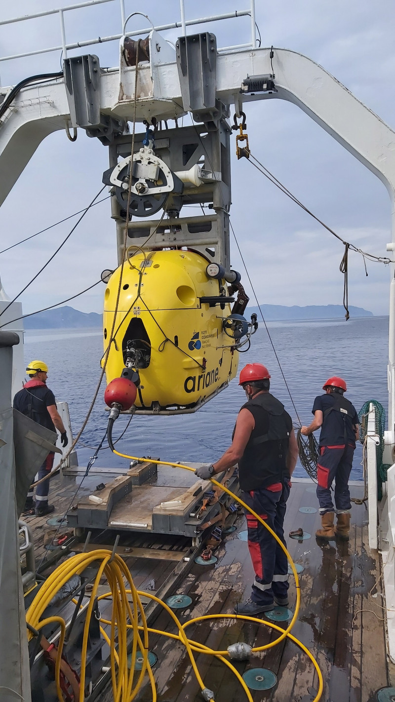
A robot, valuable helper
A valuable assistant in their research is the Ariane robotic vehicle, which has the ability to dive to a depth of up to 2,500 meters and stay there for up to six hours on each dive. Its 4K cameras record the morphology of the seabed and allow researchers to see and study the relief at a maximum speed of 0.5 meters per second. Equipped with two mechanical arms, it is also able to collect sediment in 30cm long tubes called corers. The eight sediment cores collected will help date the underwater relief.
For the research, Ariane dived nine times for a total of 26 hours and traveled a total of 13 kilometers exploring the Amorgos fault zone and other faults. It took thousands of photos, which will be used to produce 3D models that will help scientists measure seafloor deformation.
In addition, the French oceanographic ship “L’ Europe”, which is equipped with a multiband mapping system to record underwater morphology in coastal areas, also participated in the research. During the night but also during the days when there were stormy winds that prevented the robotic vessel from diving, “L’ Europe” gathered bathymetric data in the coastal zone of Anafi and Amorgos. The high-resolution bathymetric data will be used in modeling the propagation of the 1956 tsunami, in order to better understand its generation mechanism.
In addition, the researchers identified several undersea landslides possibly linked to the 1956 earthquake, which could have amplified the tidal waves.
Data processing and interpretation is currently underway in order to form a better picture of these past events and to have a better understanding of the future in one of the most geodynamically active areas of the Greek subsea area.
The first research results from the research, as reported by Mrs. Nomikou in APE-MBE, are that the sea area between Amorgos and Santorini “is geodynamically active with many geohazards. However, we now have at our disposal high-resolution geophysical data and three-dimensional relief models, which will help us to better study the deformation of the bottom after the 1956 earthquake.”
Source :Skai
I am Terrance Carlson, author at News Bulletin 247. I mostly cover technology news and I have been working in this field for a long time. I have a lot of experience and I am highly knowledgeable in this area. I am a very reliable source of information and I always make sure to provide accurate news to my readers.


