

Scientists say they are stunned by what they found about the intensity of Tonga’s volcanic eruption in January of this year.
When this submerged mountain erupted, it sent ash and water vapor into space and generated tsunami waves around the world.
Now, a survey carried out by vessels from New Zealand and the United Kingdom has completely mapped the area around this volcano in the Pacific Ocean — and has shown that the sea floor has been swept and carved by violent debris flows from a distance of more than 80 km. .
The Hunga-Tonga Hunga-Haʻapai seamount mapping exercise was conducted by the New Zealand National Institute for Water and Atmospheric Research (Niwa).
The collected data indicate that at least 9.5 cubic kilometers, perhaps as much as 10 cubic kilometers, of material was displaced during the cataclysmic event. This volume is equivalent to approximately 4,000 Egyptian pyramids.
Two-thirds refer to ash and rock ejected by the caldera (or vent) of the volcano.
“You can think of it as ‘a shotgun blast’ straight into the sky,” marine geologist and Niwa project director Kevin Mackay told BBC News.
“Some of this material went beyond the stratosphere into the mesosphere [57 km de altitude] —the tallest eruption column recorded in human history,” he added.
The remaining third was material scraped off the top and sides of the Hunga-Tonga as debris fell to sweep the ocean floor.
This transport took the form of pyroclastic density currents, which are incandescent rock avalanches. In the water, their scorching heat would have enveloped them in a kind of frictionless cushion of steam on which they could simply move at high speed.
The survey work tracked flows that were able to traverse and overcome elevations of several hundred meters.
This explains, for example, the break in the undersea fiber optic cable that connects Tonga to the global internet. A large part of the cape has been cut despite it being 50 km south of Hunga-Tonga and behind a large seafloor hill.
“Where those flows were, there’s nothing living there today. It’s like a desert 70 km from the volcano,” says Mackay. “And yet, amazingly, just below the rim of the volcano, in places that have escaped these density currents, you find life. You find sponges. They barely escaped.”
Pyroclastic flows are also part of the Hunga-Tonga tsunami story. Waves were recorded across the Pacific, but also in other ocean basins — the Atlantic and even the Mediterranean Sea.
The Niwa team says there were essentially four ways in which the water moved to generate these tsunamis: by density flows pushing the water out; by the explosive force of the eruption also pushing up the water; as a result of the dramatic collapse of the bottom of the caldera (it fell 700 meters); and by pressure waves from the atmospheric explosion acting on the surface of the sea.
At certain stages during the eruption, these mechanisms probably worked together.
A good example is the biggest wave that hit the main island of Tonga, Tongatapu, 65 km south of Hunga-Tonga. This happened just over 45 minutes after the first major eruptive explosion. A wall of water several meters high has invaded the Kanokupolu Peninsula, destroying beach resorts in the process.
Emily Lane, a natural disaster specialist at Niwa, believes that an anomaly in atmospheric pressure increased the height of the tsunami waves. “In the case of big local waves — in order to understand them correctly, I believe you have to have that atmospheric coupling as well.”
“We had a huge pressure anomaly that by itself would have generated a tsunami. So when you already have waves, you’re just adding energy to them.”
The Niwa survey, formally called the Tonga Eruption Seabed Mapping Project (TESMaP), was undertaken in two parts.
The first leg, which mapped and sampled the sea floor around the volcano, was conducted by the New Zealand research vessel Tangaroa.
The second leg, directly above the mountain, was taken by the British robot boat USV Maxlimer. Operated by Sea-Kit International from a control room 10,000 miles away in Tollesbury, UK, this unmanned vehicle was able to identify ongoing, albeit relatively moderate, volcanic activity.
The boat did this by tracking a persistent layer of ash in the caldera to its source — a new volcanic vent about 200 meters down.
Satellite images show magnitude of tsunami impact in Tonga
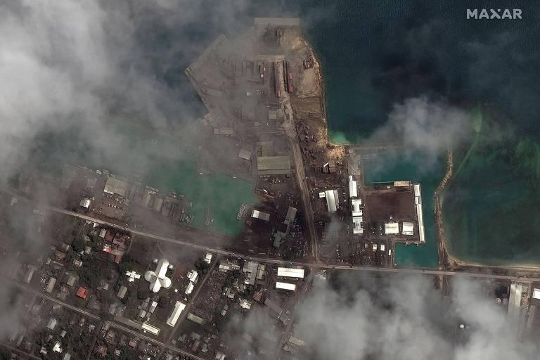
Port facilities in the country’s capital, Nukualofa, on 29.Dec.21, before the eruption of the Hunga Tonga-Hunga Ha’apai volcano and the tsunami, and this Tuesday, 19.Jan.22- – Maxar Technologies/Reuters
It is striking that only six people died in the January 15th event, and two of them in Peru. It could have been a lot worse.
All TESMaP results will ultimately contribute to risk mitigation, preparing Pacific nations located near the volcanic zone, which runs from the North Island of New Zealand to Samoa. They’ll have a better idea now of where to build infrastructure and how to secure it; and, most importantly, assess the scale of risk they face.
“We’ve always underestimated undersea volcanoes,” says Taaniela Kula of the Geological Survey of Tonga. “There are another five around Tongatapu. That means we need more planning and urgently.”
TESMaP was funded by Japan’s Nippon Foundation and organized with the help of the Seabed2030 project, an international effort to properly map the Earth’s ocean floor.
This text was originally published here.
With a wealth of experience honed over 4+ years in journalism, I bring a seasoned voice to the world of news. Currently, I work as a freelance writer and editor, always seeking new opportunities to tell compelling stories in the field of world news.


