

It’s about mapping the minerals that formed after they were weathered by water – The ‘red planet’ turns out to be more complex than we thought
The first “water map” of the planet Mars was created by its scientists ESAoffering to NASA a huge tool in view of exploring the planet and establishing a human colony there. This is a map that indicates the points with “water rocks”, that is, rocks that were formed and shaped by the input of water.
Specifically, the map shows their locations and abundances water minerals. These come from rocks that have been chemically altered by the action of water in the past and have typically turned into clay and salts.
Watch the video released by ESA:
On Earth, clays form when water interacts with rocks, with different conditions creating different types of clays. For example, clay minerals such as smectite and vermiculite form when relatively small amounts of water interact with the rock and thus retain mostly the same chemical elements as the original volcanic rocks. In the case of smectite and vermiculite these elements are iron and magnesium. When the amount of water is relatively high, the rocks can weather more. Soluble elements tend to be washed away, leaving aluminum-rich clays such as kaolin behind.
The big surprise is the prevalence of these minerals. Ten years ago, planetary scientists knew about 1000 eruptions on Mars. This made them interesting as geological oddities. However, the new map has reversed the situation, revealing hundreds of thousands of such areas in the oldest parts of the planet.
“This work has now proven that when you study ancient soils in detail, not seeing these minerals is actually the strange thing,” says John Carter, Institut d’Astrophysique Spatiale (IAS) and Laboratoire d’Astrophysique de Marseille ( LAM). Université Paris-Saclay and Aix Marseille Université in France.
This is yet another example for our understanding of the red planet’s history. From the smaller number of water minerals previously known to exist, it was likely that water was limited in extent and duration. Now, there is no doubt that water has played a huge role in shaping geology around the planet.
Now, the big question is whether the water was persistent or limited to smaller, more intense episodes. While not yet providing a definitive answer, the new results certainly give researchers a better tool in the search for the answer.
“I think we’ve collectively oversimplified Mars,” says John. He explains that planetary scientists tended to believe that only a few types of clay minerals on Mars were formed during its wet period, then as the water gradually dried up, the salts were produced across the planet.
This new map shows that the planet is more complex than we thought. While many of the Martian salts likely formed later than the clays, the map shows many exceptions where there is close mixing of salts and clays, and some salts that are assumed to be older than some clays.
“The evolution from a lot of water to a lack of water is not as clear as we thought, the water did not just stop overnight. We see a huge variety of geological settings, so no single process or simple timeline can explain the evolution of Martian mineralogy. This is the first result of our study. The second is that if you exclude life processes on Earth, Mars exhibits a variety of mineralogy in geological settings, just like Earth does,” he says.
In other words, the closer we look, the more complex Mars’ past becomes.
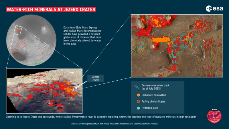
The OMEGA and CRISM instruments are ideal for this research. Their data sets are highly complementary, operating in the same wavelength range and sensitive to the same minerals. CRISM uniquely provides high-resolution spectral imaging of the surface (up to 15 m/pixel) for highly localized patches of Mars, making it best suited for mapping small areas of interest, such as rover landing sites. For example, mapping shows that Jezero Crater, where NASA’s 2020 Rover Perseverance is currently exploring, displays a rich variety of hydrated minerals.
OMEGA, on the other hand, provides global coverage of Mars at higher spectral resolution and with a better signal-to-noise ratio. This makes it more suitable for global and regional mapping and distinguishing between different alteration minerals.
Suggests suitable spots for landing missions
This work also gives mission planners some great candidate sites for future landing sites – for two reasons. First, hydrous minerals still contain water molecules. Together with known sites of buried water-ice, this provides potential water extraction sites for In situ Resource Development, key to establishing human bases on Mars. Clays and salts are also common building materials on Earth.
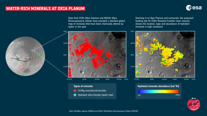
Second, even before humans go to Mars, hydrous minerals provide fantastic sites for science. As part of this mineral mapping campaign, the clay-rich site of Oxia Planum was discovered. These ancient clays include the iron- and magnesium-rich minerals smectite and vermiculite. Not only can they help unlock the planet’s past climate, but they are perfect sites to investigate whether life once began on Mars. Therefore, Oxia Planum was proposed and eventually selected as the landing site for ESA’s Rosalind Franklin rover.
Read the News today and get the latest news. Follow us on Google News and be the first to learn all the news from Skai.gr.
I have over 8 years of experience in the news industry. I have worked for various news websites and have also written for a few news agencies. I mostly cover healthcare news, but I am also interested in other topics such as politics, business, and entertainment. In my free time, I enjoy writing fiction and spending time with my family and friends.


