

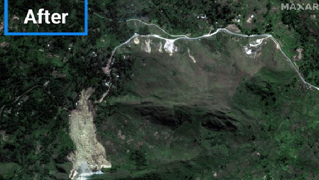
Satellite images from before and after the landslide show a huge part of the site in the Enga mountain region has literally come off
The extent of the devastating landslide, which left 2,000 people buried under tons of rock and mud, satellite images and video reveal.
Over 2,000 buried alive in Papua New Guinea Landslide
Locals in northern Papua New Guinea seen searching desperately with shovels and bare hands through muddy rubble and debris, video from the UN shows after a massive landslide swept through the area
India extends immediate… pic.twitter.com/z1zEVUgvGk
— DD News (@DDNewslive) May 28, 2024
Satellite images from before and after the landslide show a huge part of the site in the Enga mountain region has literally come off.
Image before the landslide
Image after the landslide
More than 150 houses in the village of Giambali were buried under tons of mud and rocks, according to local authorities. The country’s National Disaster Center said there were fears nearly 2,000 people were buried inside their homes.
The landslide hit the remote village of Kaokalam, about 600 kilometers northwest of the capital Port Moresby, at about 3am. local time on Friday, leaving behind a volume of dirt the size of four football fields.
The phenomenon occurred while the residents of the area were sleeping in their homes with the rescuers fighting against time to reach such a remote place. Residents were trying to dig with their hands to free people.
The area remained unstable, with smaller landslides occurring regularly and endangering rescue teams. The government ordered the evacuation of nearly 7,000 people from the site.
Source :Skai
With a wealth of experience honed over 4+ years in journalism, I bring a seasoned voice to the world of news. Currently, I work as a freelance writer and editor, always seeking new opportunities to tell compelling stories in the field of world news.


